What it is
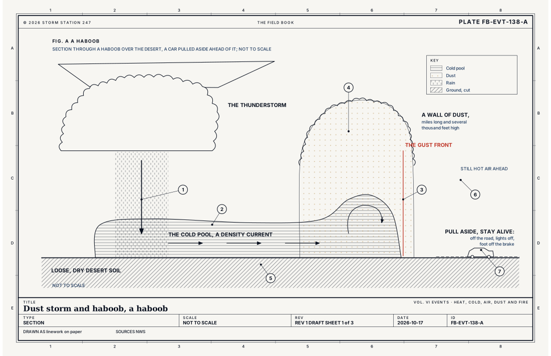
A dust storm is wind lifting so much dust from dry ground that the air turns opaque and the visibility falls toward nothing. A haboob is the kind a thunderstorm makes. The storm's downdraft, cooled by its rain and by the rain evaporating as it falls, reaches the ground and spreads out across the desert, and its leading edge lifts the loose soil into a wall of dust that can be miles long and several thousand feet high. It arrives suddenly, and it usually lasts only a few minutes.
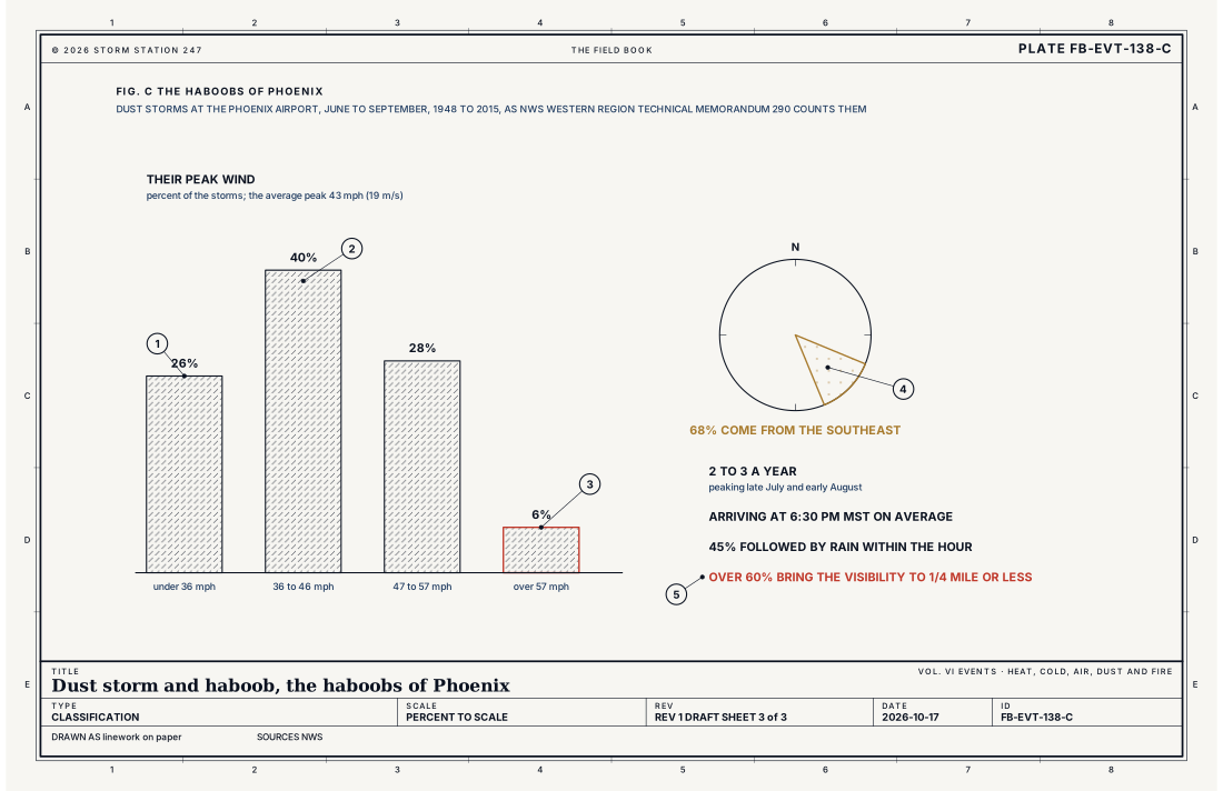
Dust storms can happen anywhere in the United States, but they are most common in the Southwest. At the Phoenix airport, haboobs come 2 to 3 times a year in the summer monsoon, most in late July and early August, as the Weather Service's own study of the record from 1948 to 2015 found. The danger is on the roads: visibility can drop suddenly from miles to near zero, and drivers who keep going cause chain collisions.
What it is not
It is not blowing dust from a large weather system. A strong wind behind a cold front or a deep low can raise dust over a wide area for hours, mostly in the fall, winter and spring; that is warned by zone, as a Blowing Dust Advisory or Warning, Blowing dust FB-EVT-137. A haboob comes from one storm's outflow and is warned in a polygon.
It is not the downburst itself. The storm's downdraft striking the ground is a microburst, Microburst and heat burst FB-EVT-020; the haboob is what its spreading outflow raises.
It is not smoke. Dense smoke from fire also hides the road, Dense smoke FB-EVT-136, and has its own advisory.
Lookalikes
- Blowing dust
- Dust raised by the wind of a large weather system, widespread and longer lasting, warned by zone, Blowing dust FB-EVT-137. A haboob comes from one storm's outflow, in a polygon.
- A dry microburst
- The storm's downdraft itself, striking the ground and spreading, Microburst and heat burst FB-EVT-020. A haboob is what the spreading outflow raises.
- Smoke
- Dense smoke from fire also hides the road, Dense smoke FB-EVT-136, and is warned by its own advisory.
Machine
Cold air, spreading
Under a desert thunderstorm, the air below the cloud base is deep, hot and dry. Rain falling through it evaporates, and evaporation cools the air, which grows dense and sinks to the ground. There it spreads out as a cold pool, a layer of cold air running across the desert like water poured onto a floor. Meteorologists call it a density current: the denser air pushes under the lighter air ahead of it, and its leading edge, the gust front, rises into a raised head where the wind is strongest. Fig. A draws it.
Lifting the dust
Where the gust front's wind reaches 25 mph or more, it lifts loose soil: bare desert, abandoned or freshly tilled farmland, dirt roads, construction sites. Rain in the weeks before helps hold the soil down, by forming a crust and growing plants; a dry season, or ground just tilled, lets the wind lift dust more easily. The head's swirling motion carries the dust up thousands of feet, and the cold pool behind it fills with dust too. At Phoenix, the average dust storm's peak wind was 43 mph, and only 6 percent passed 57 mph.
Outflows that travel
In Arizona the storms form over the mountains in the afternoon, and their outflows run down the slopes into the valleys, merge, and travel far from the storms that made them. Phoenix lies where several valleys meet, so outflows arrive from more than one direction; 68 percent of its haboobs have come from the southeast, at 6:30 in the evening on average. Nearly half are followed by rain within the hour, as the storms arrive behind their outflow.
Why the light fails
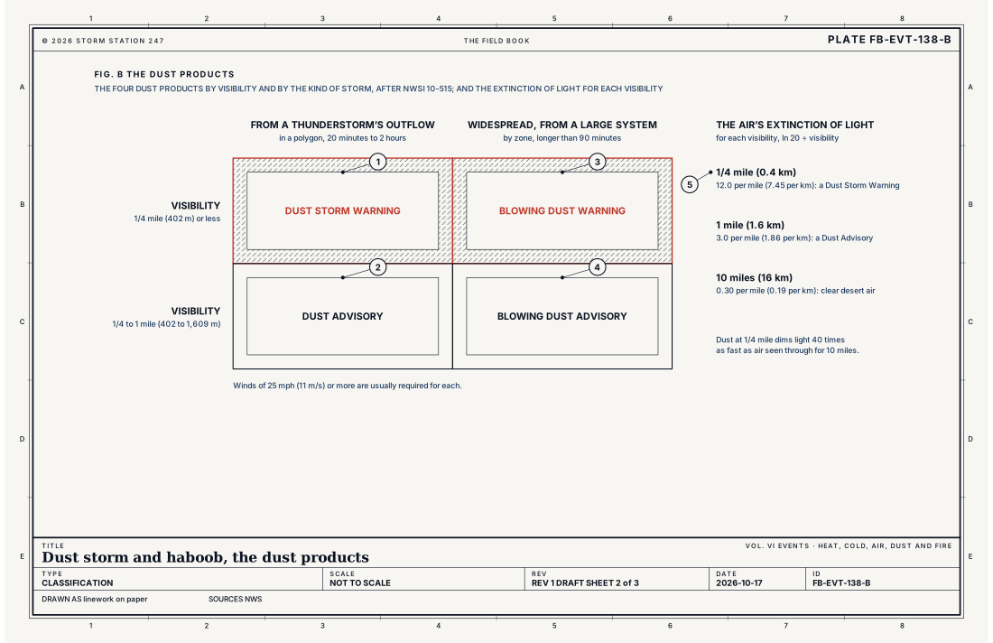
Visibility is set by how fast the air dims light. The equation below gives the meteorological optical range, the distance along which a beam is dimmed to 5 percent. Dust thick enough for a Dust Storm Warning, at 1/4 mile, dims light 40 times as fast as clear desert air that can be seen through for 10 miles. Fig. B sets the products against their visibilities.
- Dust Storm Warning
- Dust Advisory
- Blowing Dust Warning
- Blowing Dust Advisory
- The extinction of light for each visibility
- Peak wind under 36 mph, 26 percent
- 36 to 46 mph, 40 percent
- Over 57 mph, 6 percent
- From the southeast, 68 percent
- Visibility 1/4 mile or less, over 60 percent
Ingredients
- Loose, dry soil: desert, abandoned or freshly tilled farmland, dirt roads
- A thunderstorm whose downdraft, cooled by rain and its evaporation, spreads over the ground as a cold pool
- Winds of 25 mph or more at the ground, from the outflow's head
- Little recent rain, so no crust or new growth holds the soil down
Scales
- time
- minutes for most; up to 2 hours for a Dust Storm Warning
- horizontal
- a wall of dust miles long, moving with the storm's gust front
- vertical
- several hundred feet to several thousand feet high
- orlanski
- meso-gamma to meso-beta
Equations
Visibility and the extinction of light
- the meteorological optical range, the path along which a beam of light is dimmed to 5 percent, mi
- the extinction coefficient of the air, how much of the light it scatters and absorbs along each mile, per mile
Assumes Air dimming the light evenly along the path, by the exponential law of extinction; the meteorological optical range is the WMO's measure of visibility, the one the airport stations' sensors report.
Working form A Dust Storm Warning's 1/4 mile (0.4 km) is an extinction of 12.0 per mile (7.45 per km); a Dust Advisory's 1 mile (1.6 km), 3.0 per mile (1.86 per km); air seen through for 10 miles (16 km), 0.30 per mile (0.19 per km). Dust thick enough for a warning dims light 40 times as fast as clear desert air.
Signatures
- surface
- a sudden wind shift and gust; the temperature dropping; the visibility falling to near nothing within minutes
- radar
- a fine line of returns along the outflow's edge; moving away from the storms
- satellite
- thunderstorms over the mountains in the afternoon; the dust plume itself on visible imagery; if no cloud hides it
- sounding
- a deep; dry; well mixed layer below the cloud base; which lets rain evaporate and cool the downdraft
Numbers
| Quantity | Value, and the kind of number it is |
|---|---|
| Dust Storm Warning | Dust reducing the visibility to 1/4 mile (0.4 km) or less, occurring, imminent or highly likely; winds of 25 mph (11 m/s) or more usually requiredStandard, Directive 10-515 |
| Dust Advisory | Dust reducing the visibility to 1 mile (1.6 km) or less but more than 1/4 mile (0.4 km); winds of 25 mph (11 m/s) or more usually requiredStandard, Directive 10-515 |
| How long one runs | A polygon valid for 20 minutes to 2 hoursStandard, Directive 10-515 |
| Blowing Dust Warning and Advisory | The same visibilities from widespread dust raised by a large weather system, generally for longer than 90 minutes, issued by zoneStandard, Directive 10-515 |
| A haboob | A wall of dust up to about 6,600 ft (2 km) high, moving with a thunderstorm's gust frontStandard, Technical Memorandum NWS-WR 290 |
| Haboobs at Phoenix | 2 to 3 a year at the airport, June to September, 1948 to 2015; peaking late July and early AugustTypical, Technical Memorandum NWS-WR 290 |
| Where they come from | 68 percent arrive at Phoenix from the southeast, at 6:30 pm MST on averageTypical, Technical Memorandum NWS-WR 290 |
| Their peak wind | 43 mph (19 m/s) on average; over 57 mph (25 m/s) in only 6 percentTypical, Technical Memorandum NWS-WR 290 |
| Their visibility | 1/4 mile (0.4 km) or less in over 60 percentTypical, Technical Memorandum NWS-WR 290 |
| Rain after | 45 percent followed by rain at the airport within the hourTypical, Technical Memorandum NWS-WR 290 |
| How long one lasts | Usually only a few minutesTypical, Dust Storms and Haboobs |
| Meteorological optical range | The path along which a beam is dimmed to 5 percentStandard, Guide to Instruments and Methods of Observation (WMO-No. 8) |
| If caught driving | Pull off the pavement as far as possible, stop, turn off the lights, set the emergency brake and take the foot off the brake pedalStandard, Dust Storms and Haboobs |
How the station sees it
The airport weather stations on this site measure the visibility and the wind each minute, and a haboob shows as a sudden wind shift and gust, a drop in temperature and a collapse in visibility within minutes. The radar on the live map shows the storms and, often, a fine line moving out ahead of them: the edge of the outflow. Over 60 percent of the Phoenix dust storms brought the airport's visibility to 1/4 mile or less.
- Airport weather stations: the visibility, the wind and its gusts, minute by minute
- The radar on the live map: the storms and the edge of their outflow
- Severe Alerts: every Dust Storm Warning and Dust Advisory in force, each with its own report
How it is warned
A Dust Storm Warning is issued when dust is reducing the visibility to 1/4 mile or less, or is about to, and a Dust Advisory when it is reducing it to 1 mile or less; winds of 25 mph or more are usually required for either. Both are drawn as polygons for 20 minutes to 2 hours, for the short, local dust that thunderstorms raise. Widespread dust from a large weather system, lasting more than 90 minutes, is given a Blowing Dust Warning or Advisory by zone instead.
Do not drive into a dust storm. If dense dust is blowing across or toward the road, pull off the pavement as far as possible, stop, turn off all the lights, set the emergency brake and take your foot off the brake pedal, so no driver behind follows your lights off the road. Pull aside, stay alive.
| VTEC | Phenomenon | The alerts that carry it |
|---|---|---|
DS | dust storm | Dust Storm Warning |
Weather radio (SAME) codes: DSW
See also
- Blowing dust FB-EVT-137
- Microburst and heat burst FB-EVT-020
- Dense smoke FB-EVT-136
- Thunderstorm FB-EVT-001
- ASOS FB-INS-002
- How to read a warning FB-STN-001
Sources
- National Weather Service. Directive 10-515, WFO Non-Precipitation Weather Products Specification.
- National Weather Service. Technical Memorandum NWS-WR 290, Blowing Dust and Dust Storms: One of Arizona's Most Underrated Weather Hazards (2016).
- National Weather Service. Dust Storms and Haboobs.
- World Meteorological Organization. Guide to Instruments and Methods of Observation (WMO-No. 8).
Definition after the Directive 10-515, WFO Non-Precipitation Weather Products Specification. Plate FB-EVT-138, revision 1, 2026-10-17. The number is permanent; cite it.