What it is
Over the sea and the Great Lakes, the wind is warned in steps that a mariner plans a voyage around. The Weather Service sets them in knots, the speed a ship's log reads, and each step is a different decision for a different boat.
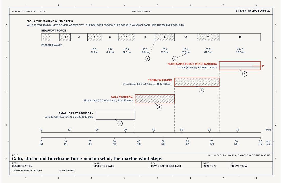
A Small Craft Advisory is the first step: a sustained wind or frequent gusts of 23 to 38 mph (20 to 33 knots), as each region sets it, or seas of 4 ft (1.2 m) or more. A Gale Warning starts at 39 mph (17.5 m s⁻¹, 34 knots). A Storm Warning starts at 55 mph (24.7 m s⁻¹, 48 knots). A Hurricane Force Wind Warning starts at 74 mph (32.9 m s⁻¹, 64 knots). Fig. A sets the four on one scale of speed with the Beaufort forces, the older scale they grew from.
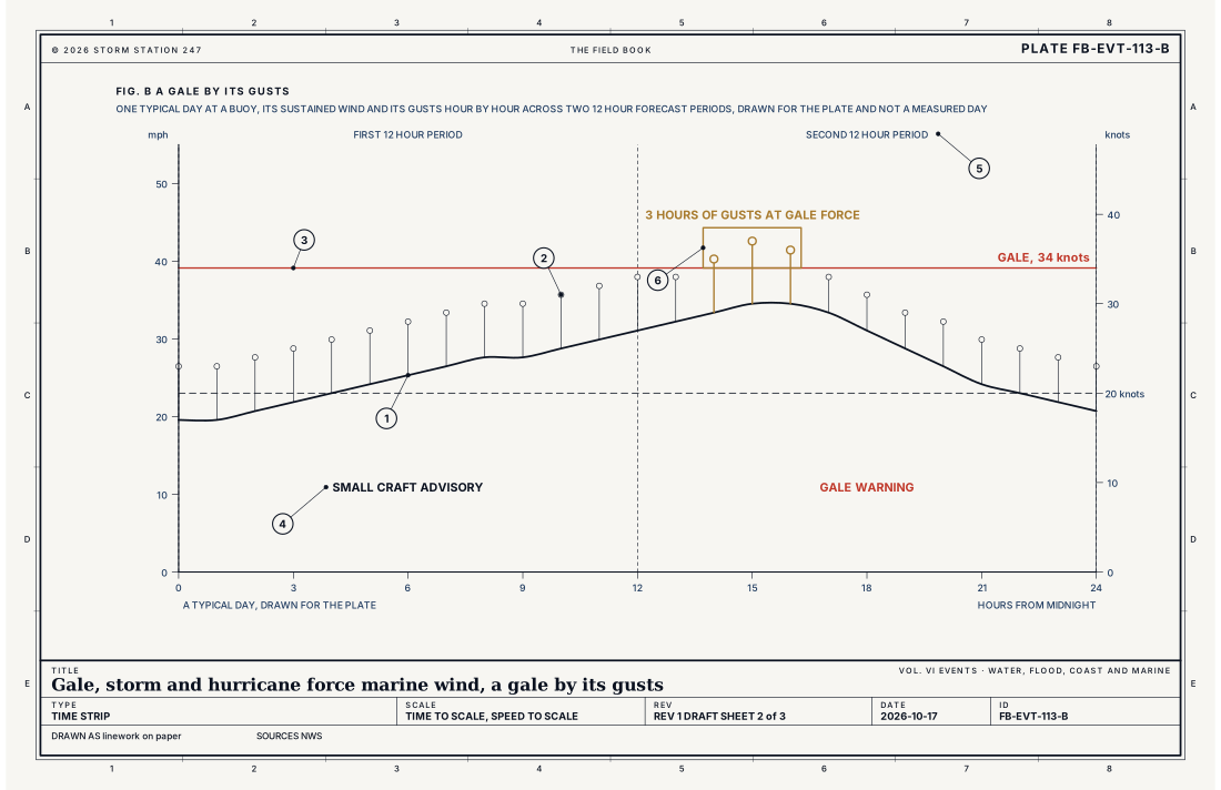
Two words decide which step applies. The wind can meet a step by holding steady at it, the sustained wind, or by gusting to it often enough. Frequent gusts, in the directive's own words, are gusts that blow for 2 hours or more within one 12 hour forecast period. Fig. B draws a day where the sustained wind never reaches gale force and the gusts still make it a gale.
What it is not
It is not a tropical cyclone's wind. Every one of these warnings is for wind not directly associated with a tropical cyclone. When a tropical storm or a hurricane makes the wind, the hurricane products warn it on the water as they do on land, Hurricane FB-EVT-043.
It is not a thunderstorm's wind. A storm that crosses the water with gusts of 39 mph (34 knots) or more, hail of 3/4 in (1.9 cm) or more, or a waterspout is warned by a Special Marine Warning, which lasts two hours or less. Its plate is the thunderstorm's, Thunderstorm FB-EVT-001.
It is not the sea itself. Waves that are too high or too steep for safe passage are warned as hazardous seas, Hazardous seas FB-EVT-114, and ice that builds on a ship in a cold wind is freezing spray, Freezing spray FB-EVT-115. On land, the same kind of wind is warned as a high wind, on lower numbers, High wind FB-EVT-150.
Lookalikes
- Special Marine Warning
- A thunderstorm's wind, hail or waterspout over the water, for two hours or less, is warned by its own product, and drawn on the thunderstorm plate, Thunderstorm FB-EVT-001.
- Tropical storm or hurricane wind
- When a tropical cyclone makes the wind, the hurricane products warn it on the water as on land, Hurricane FB-EVT-043.
- High wind on land
- The same steps on land are the High Wind Warning and the Wind Advisory, on lower numbers, High wind FB-EVT-150.
- Hazardous seas
- Waves too high or too steep for safe passage are warned as seas, not as wind, Hazardous seas FB-EVT-114; ice building on a ship is freezing spray, Freezing spray FB-EVT-115.
Machine
A low over open water
The strongest of these winds blow around deep lows over the open ocean and the Great Lakes, most often in the cold half of the year, when the contrast between polar air and warmer water is greatest. The wind is set by the pressure gradient, the same balance drawn on the high wind plate: isobars packed close together balance a fast wind. A nor'easter off the Atlantic coast, Nor'easter FB-EVT-066, and the deep lows of the Gulf of Alaska and the Bering Sea are among the lows that raise storm and hurricane force wind at sea. A small, intense low that forms over cold seas can do it too: the polar low, Polar low FB-EVT-070.
Why the water lets the wind down
Over land, trees, hills and buildings slow the lowest air, and the fast wind a little way up stays aloft unless the afternoon sun stirs it down. Over water there is far less to slow it. When cold air crosses warmer water, the water heats it from below, the lowest few thousand feet overturn, and the faster wind at the top of that layer is carried down to the surface in gusts. This is why a cold wind behind a front over a warm lake can blow a gale while the shore a few miles inland is only breezy.
The sea the wind builds
The wind does its harm through the sea it raises. It builds waves over the length of open water it blows across, the fetch, and over the hours it keeps blowing. The Beaufort scale gives a probable height for each force: 18 ft (5.5 m) at force 8, a gale; 29 ft (8.8 m) at force 10, a storm; and 45 ft (13.7 m) or more at force 12, hurricane force. Waves near the highest of these come only from a long fetch and many hours of wind; a lake's waves are shorter and steeper.
The push grows with the square
The equation below gives the push of the wind on a surface square to it, from its density and its speed. A gale's lowest wind, 39 mph (17.5 m s⁻¹), pushes 3.9 lb on every square foot (187 Pa) of a sail or a deckhouse. At hurricane force, 74 mph (32.9 m s⁻¹), the push is 13.9 lb (664 Pa). The speed is less than twice as great, and the push is more than three and a half times. That is the difference between a hard sail and a broken rig.
- The sustained wind
- The gusts
- Gale force, 34 knots
- The first 12 hour period, a Small Craft Advisory
- The second 12 hour period
- Gusts at gale force for 3 hours, frequent gusts
- The coast
- Coastal waters, out to a line set zone by zone
- Offshore waters, several hundred nautical miles out
- The high seas
- Nearshore waters, within 5 nmi (5.8 mi) of a lakeshore
- The open lake
Ingredients
- A deep low over open water, and the steep pressure gradient around it, most often in the cold half of the year
- Cold air crossing warmer water, which stirs the lowest air and brings the faster wind above it down to the surface
- A long run of open water, the fetch, over which the wind builds the sea it is blowing
- Or a coast, a strait or a gap between mountains that squeezes the wind and speeds it up
Scales
- time
- hours to a few days, for one gale
- horizontal
- one marine zone, tens of miles across, up to an ocean low more than a thousand miles (1,600 km) across
- vertical
- the lowest few thousand feet over the water
- orlanski
- meso-alpha to synoptic
Equations
The push of the wind
- the dynamic pressure of the wind on a surface square to it, Pa
- the density of the air, kg m⁻³
- the wind speed, m s⁻¹
Assumes Air brought to rest against a flat surface at sea level density, 1.225 kg m⁻³; a sail, a hull or a deckhouse takes a fraction or a multiple of it according to its shape.
Working form A gale's lowest wind, 39 mph (17.5 m s⁻¹, 34 knots), pushes 3.9 lb on every square foot (187 Pa); hurricane force, 74 mph (32.9 m s⁻¹, 64 knots), pushes 13.9 lb (664 Pa). The speed is less than twice as great, and the push is more than three and a half times.
Signatures
- sounding
- cold air over much warmer water; the lowest few thousand feet mixed and unstable; a strong wind at the top of that layer
- surface
- pressure falling fast at a buoy or ship ahead of a deepening low; then rising fast behind it; the wind backing or veering sharply as a front passes; whitecaps and streaks of foam
- satellite
- a comma cloud wound tight around an ocean low; open cells of cumulus streaming over the water behind a cold front
- radar
- near the coast; fast motion of the echoes in a band of showers moving onshore
Numbers
| Quantity | Value, and the kind of number it is |
|---|---|
| Small Craft Advisory | Sustained wind or frequent gusts of 23 to 38 mph (10.3 to 17.0 m s⁻¹, 20 to 33 knots), as each region sets it; or seas or waves of 4 ft (1.2 m) or more; or waves made hazardous by their period, steepness or swellTypical, Instruction 10-315 |
| Gale Warning | Sustained wind or frequent gusts of 39 to 54 mph (17.5 to 24.2 m s⁻¹, 34 to 47 knots), occurring or forecast, and not directly associated with a tropical cycloneStandard, Instruction 10-315 |
| Storm Warning | Sustained wind or frequent gusts of 55 to 73 mph (24.7 to 32.4 m s⁻¹, 48 to 63 knots), occurring or forecast, and not directly associated with a tropical cycloneStandard, Instruction 10-315 |
| Hurricane Force Wind Warning | Sustained wind or frequent gusts of 74 mph (32.9 m s⁻¹, 64 knots) or more, occurring or forecast, and not directly associated with a tropical cycloneStandard, Instruction 10-315 |
| Frequent gusts | Gusts that blow for 2 hours or more within one 12 hour forecast periodStandard, Instruction 10-315 |
| Gale, Storm and Hurricane Force Wind Watch | Conditions favour the warning's wind within the next 12 to 60 hoursStandard, Instruction 10-315 |
| Brisk Wind Advisory | Small Craft Advisory winds expected over waters covered with iceStandard, Instruction 10-315 |
| Heavy Freezing Spray Warning | Ice building on a vessel at 0.8 in (2 cm) an hour or more, from cold water, wind, cold air and the vessel's motion togetherStandard, Instruction 10-315 |
| Beaufort force 8, gale | 39 to 46 mph (17.5 to 20.6 m s⁻¹, 34 to 40 knots); probable waves 18 ft (5.5 m), at most 25 ft (7.6 m)Standard, Beaufort Wind Scale |
| Beaufort force 10, storm | 55 to 63 mph (24.7 to 28.3 m s⁻¹, 48 to 55 knots); probable waves 29 ft (8.8 m), at most 41 ft (12.5 m)Standard, Beaufort Wind Scale |
| Beaufort force 12, hurricane | 74 mph (32.9 m s⁻¹, 64 knots) or more; probable waves 45 ft (13.7 m) or moreStandard, Beaufort Wind Scale |
| Coastal waters | Out from the shore to a line set zone by zone; the directive's own examples run 15, 20, 40 and 100 nautical miles (17, 23, 46 and 115 mi; 28, 37, 74 and 185 km)Typical, Instruction 10-310 |
| Offshore waters | From the coastal waters out several hundred nautical miles from shoreStandard, Instruction 10-311 |
| Great Lakes | The nearshore forecast covers the water within 5 nautical miles (5.8 mi, 9.3 km) of shore; the open lake forecast covers the lake beyondStandard, Instruction 10-312 |
| Special Marine Warning | A short lived hazard, 2 hours or less: thunderstorm wind or frequent gusts of 39 mph (34 knots) or more, hail of 3/4 in (1.9 cm) or more, or a waterspoutStandard, Instruction 10-313 |
How the station sees it
On the water the wind is read by buoys moored offshore and in the lakes, by stations on piers, lighthouses and platforms along the coast, by ships reporting as they go, and by the airport stations along the shore. A buoy reports the wind and the waves together: the height of the sea, the period between waves, and the direction they come from. The beach pages on this site show the nearest buoy's wind and waves for each beach, hour by hour.
The steps are judged on the sustained wind and on the gusts, so a buoy's gust column matters as much as its wind. A report that holds at 30 knots with gusts to 36 meets a gale by its gusts once they have blown for two hours of a forecast period. Before the wind arrives, the signs are a fast fall of pressure at a buoy or a ship ahead of a deepening low, a tight comma of cloud wound around it on the satellite picture, and open cells of cumulus streaming over the water in the cold air behind its front.
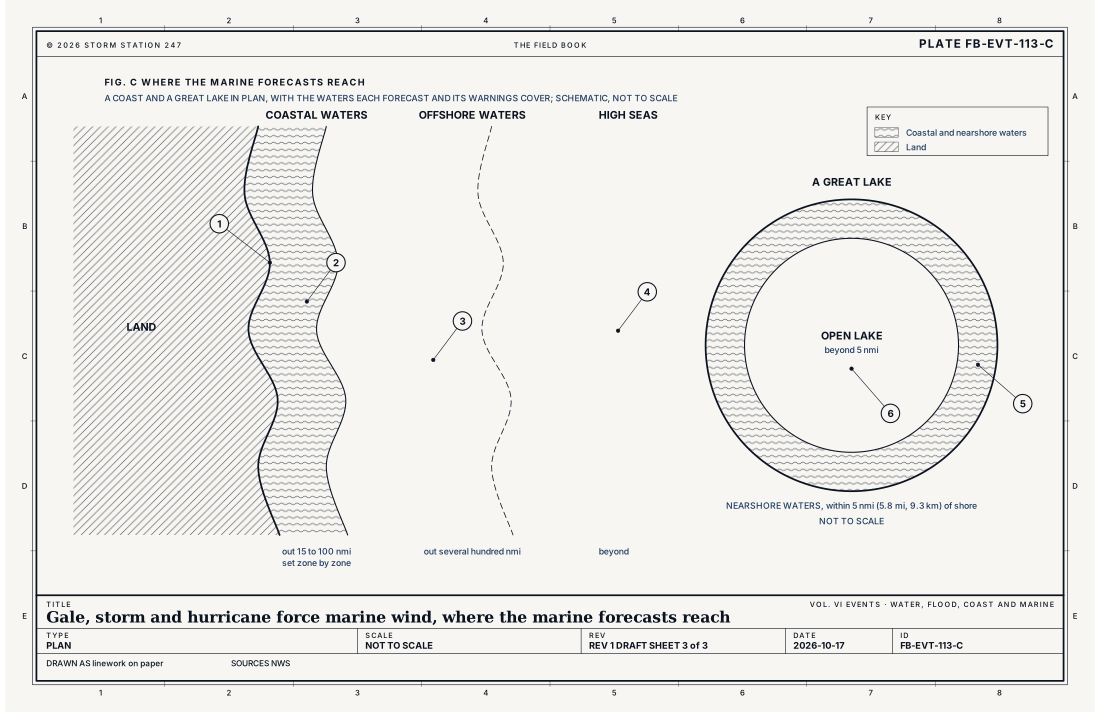
Each forecast covers its own water, and Fig. C draws them. The coastal waters forecast runs from the shore out to a line set zone by zone; the directive's examples run from 15 to 100 nautical miles. The offshore forecast runs from there out several hundred nautical miles, and the high seas forecast covers the ocean beyond. On the Great Lakes, the nearshore forecast covers the water within 5 nautical miles (5.8 mi, 9.3 km) of shore, and the open lake forecast covers the rest.
- Beaches and their wave buoys: the wind and the waves at the buoy nearest each beach, hour by hour
- Airport weather stations: the wind every minute at the coastal and lakeshore airports, 33 ft (10 m) up
- Every station on the map: all the instruments that report wind, ranked on how well they report
How it is warned
A Gale Watch, a Storm Watch or a Hurricane Force Wind Watch is issued when the warning's wind is possible in the next 12 to 60 hours. A Gale Warning, a Storm Warning or a Hurricane Force Wind Warning is issued when it is occurring or forecast, for the zones where it will blow. A Small Craft Advisory covers the step below a gale, on numbers each region sets. A Brisk Wind Advisory is the same advisory over waters covered with ice, and a Heavy Freezing Spray Warning is issued when ice will build on a ship at 0.8 in (2 cm) an hour or more.
Before a warning, check the forecast for the zone and the hours of the trip, and turn back or stay in port when the boat and its crew are not built for the step that is forecast. Secure gear and close hatches before the wind arrives. In a gale or worse, keep a lifejacket on deck, keep a radio on the weather channel, and give a lee shore a wide berth.
| VTEC | Phenomenon | The alerts that carry it |
|---|---|---|
SC | small craft | Small Craft Advisory |
GL | gale | Gale Warning; Gale Watch |
SR | storm (marine) | Storm Warning; Storm Watch |
HF | hurricane force wind | Hurricane Force Wind Warning; Hurricane Force Wind Watch |
BW | brisk wind | Brisk Wind Advisory |
See also
- High wind FB-EVT-150
- Hazardous seas FB-EVT-114
- Freezing spray FB-EVT-115
- High surf FB-EVT-107
- Hurricane FB-EVT-043
- Nor'easter FB-EVT-066
- Polar low FB-EVT-070
- Waves and swell FB-WAT-041
- Geostrophic and thermal wind FB-ENG-009
- How to read a warning FB-STN-001
Sources
- National Weather Service. Instruction 10-315, Marine Weather Message.
- National Weather Service. Instruction 10-310, Coastal Waters Forecast.
- National Weather Service. Instruction 10-311, Offshore, NAVTEX, and High Seas Forecasts.
- National Weather Service. Instruction 10-312, Great Lakes Marine Services.
- National Weather Service. Instruction 10-313, Special Marine Warnings.
- National Weather Service. Beaufort Wind Scale.
- NOAA, NASA and the U.S. Air Force. U.S. Standard Atmosphere, 1976.
Definition after the Instruction 10-315, Marine Weather Message. Plate FB-EVT-113, revision 1, 2026-10-17. The number is permanent; cite it.