What it is
A frost or a freeze is the cold of one night. Under a clear sky with little or no wind, the ground loses its warmth to space, the air touching it cools with it, and by dawn the grass, the leaves and the car roofs can be below freezing while the air a few feet up is still above it. Tender plants die, crops are lost, and pipes left outdoors can burst.
The Weather Service warns it in three steps, and only while crops and gardens are growing, in a season each office sets for its own area. A Frost Advisory is issued for a night whose lowest temperature at the shelter, the instrument screen 4.1 to 6.6 ft (1.25 to 2 m) above the grass, is forecast to be 33 to 36 °F (0.6 to 2.2 °C), on a night with light wind and clear skies. A Freeze Warning is issued for 32 °F (0 °C) or below. A Freeze Watch is issued when freezing is possible in the next 12 to 48 hours. A hard freeze, below about 28 °F (−2.2 °C), is named in the words of the Freeze Warning. Fig. B sets them on one scale.
What it is not
It is not wind chill. A cold wind makes skin lose heat faster, and that is warned as cold, Wind chill event FB-EVT-093. A frost needs the opposite: no wind at all.
It is not a cold wave. Days of arctic air that keep the temperature below freezing all day long are a cold wave, Cold wave and arctic outbreak FB-EVT-132, and its products are the cold weather products. A frost is one night's cold under a clear sky, often after a mild afternoon.
It is not the ice crystals themselves. The white deposit on the grass is drawn with dew and rime on its own plate, Dew, frost and rime FB-WAT-021. This plate is the night that makes it, and the warnings for it.
Lookalikes
- Wind chill
- A cold wind makes skin lose heat faster, and that is warned as cold, Wind chill event FB-EVT-093. A frost needs the opposite: no wind.
- A cold wave
- Days of arctic air that keep the temperature below freezing all day are a cold wave, Cold wave and arctic outbreak FB-EVT-132; a frost is one night's cold under a clear sky.
- Dew, frost and rime
- The deposit itself, the white ice on the grass, is drawn with dew and rime, Dew, frost and rime FB-WAT-021; this plate is the night that makes it and the warnings for it.
Machine
The ground glows all night
Everything warm glows in the infrared, and the ground is no exception. The equation below gives the glow: it rises with the fourth power of the temperature. Grass at 50 °F (283.15 K) sends out about 364 W m⁻², and at 32 °F (273.15 K) still 316 W m⁻². By day the sun more than makes up for it. After sunset nothing does, and the ground cools from the top down. The full balance of sunlight and glow is drawn on Radiation budget FB-ENG-007.
A clear sky lets it go
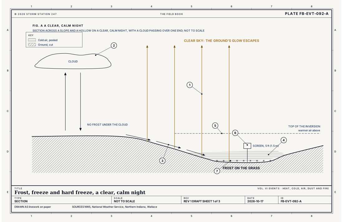
What the ground keeps depends on what comes back. Water vapour and cloud glow too, and a deck of cloud sends back nearly as much as the ground sends up, so a cloudy night stays mild. A clear, dry sky sends back far less, and the ground's loss goes on all night. Fig. A draws both: frost under the clear sky, none under the cloud. This is why a single passing cloud deck can save a crop, and why the coldest nights come under the middle of a clear, dry high.
Calm keeps the cold at the ground
The ground cools only the air touching it. With no wind to stir it, that cold air stays put, and the night builds an inversion: the air coldest at the ground and warmer a few hundred feet up. On a clear, calm night the grass can be 4 to 9 °F (2 to 5 °C) colder than the air at screen height. The Stevenson screen plate draws the lowest 10 feet of such a night, Stevenson screen and siting FB-INS-009. That gap is why a Frost Advisory starts at 36 °F at the screen: the grass below it can already be at freezing. A breeze of even a few miles an hour mixes the warmer air down and stops it.
Cold air runs downhill
Cold air is denser than the warmer air around it, so on a calm night it slides down the slopes and pools in the lowest ground. A valley floor or a hollow can freeze while the slope a few hundred feet up stays clear of frost. Growers plant orchards and vines on slopes for this reason, and the country stations in low ground read colder than the town and its paving.
What the dew point decides
As the ground cools it reaches the dew point of the air, and water comes out of the air onto it. If that happens above freezing it is dew; below freezing, white frost. In dry air the night can fall well below 32 °F with little or no white frost at all. Plants still freeze, and a freeze with no frost to see is easy to miss.
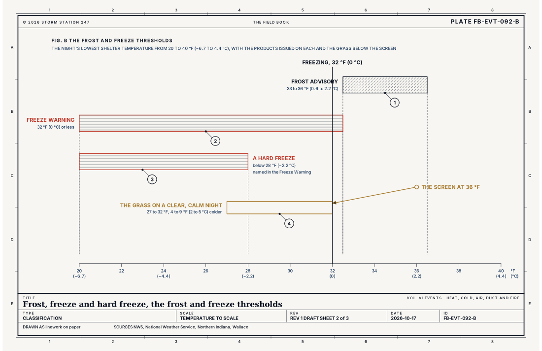
- Frost Advisory, 33 to 36 °F (0.6 to 2.2 °C)
- Freeze Warning, 32 °F (0 °C) or less
- A hard freeze, below 28 °F (−2.2 °C)
- The grass, 4 to 9 °F (2 to 5 °C) below the screen
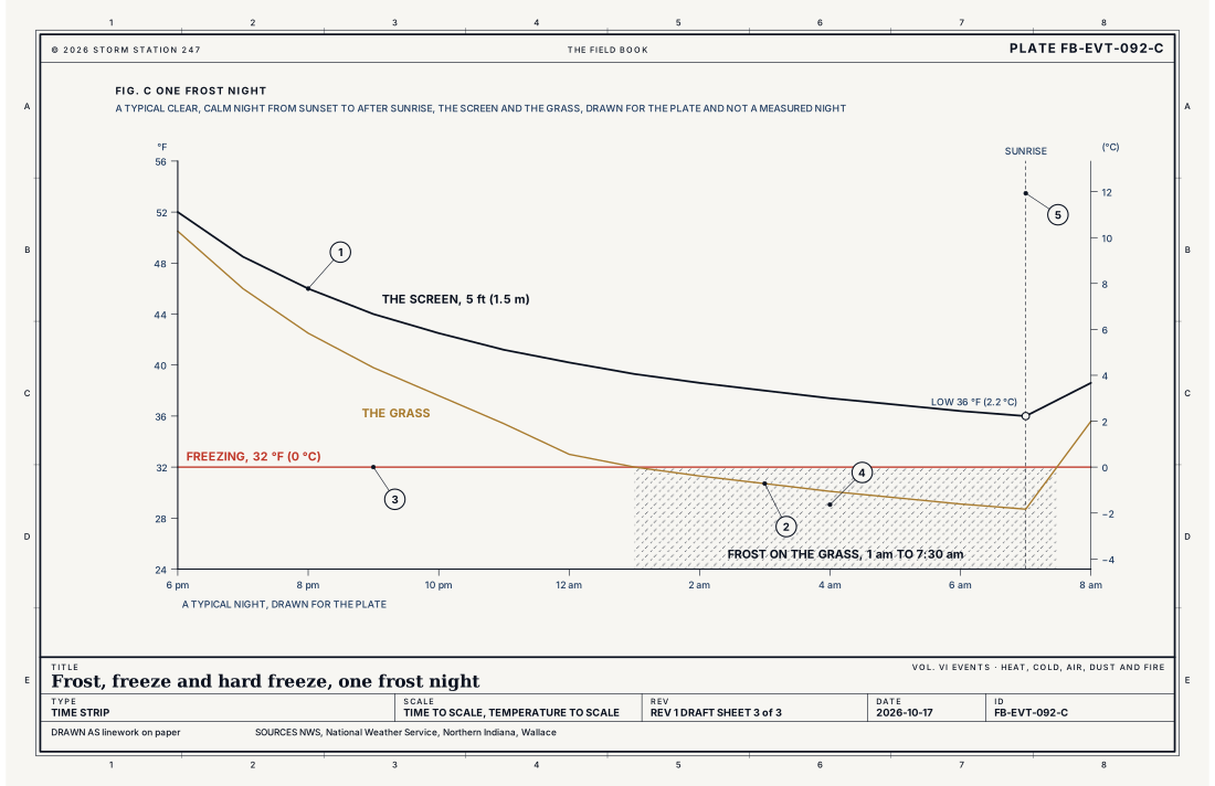
- The screen, 5 ft (1.5 m)
- The grass
- Freezing, 32 °F (0 °C)
- Frost on the grass
- Sunrise
Ingredients
- A clear sky, so the ground's glow escapes to space with no cloud to send it back
- Light wind or calm, so the coldest air at the ground is not mixed with the warmer air above
- Dry air, so the night cools far before the dew point stops it
- Low ground, where the cold air slides down the slopes and pools
Scales
- time
- one night, from sunset to just after sunrise
- horizontal
- a hollow or a valley floor colder than the slope beside it, across a region under one clear high
- vertical
- the lowest few feet of air over the ground, inside an inversion a few hundred feet deep
- orlanski
- micro-alpha to meso-beta
Equations
The glow of the ground
- the infrared energy a surface sends out, W m⁻²
- its emissivity, near 1 for grass, soil and leaves in the infrared
- the Stefan Boltzmann constant, 5.670 × 10⁻⁸ W m⁻² K⁻⁴
- the surface temperature, K
Assumes The surface taken as a black body, emissivity 1; what it loses on a clear night is this glow less the much weaker glow it receives from a clear sky, and a cloud deck sends back nearly as much as it receives.
Working form Grass at 50 °F (283.15 K) glows 364 W m⁻², and at 32 °F (273.15 K) still 316 W m⁻². It never stops glowing; it only cools more slowly as it gets colder, the glow falling about 13 per cent between 50 and 32 °F.
Signatures
- sounding
- a shallow inversion at the ground by midnight; the air warmer a few hundred feet up than at the surface; dry air above it
- surface
- the temperature falling fast after sunset and slowest near dawn; the wind calm; the dew point low; the lowest readings in the valleys and at country stations; the highest in towns
- satellite
- a clear sky under a high; cloud only at its edges
- radar
- nothing; the sky is clear
Numbers
| Quantity | Value, and the kind of number it is |
|---|---|
| Frost Advisory | Minimum shelter temperature forecast to be 33 to 36 °F (0.6 to 2.2 °C), during the locally defined growing season, on nights with light wind and clear skiesStandard, Directive 10-515 |
| Freeze Warning | Minimum shelter temperature forecast to be 32 °F (0 °C) or less, during the locally defined growing seasonStandard, Directive 10-515 |
| Freeze Watch | Freeze Warning temperatures possible in the next 12 to 48 hours, during the locally defined growing seasonStandard, Directive 10-515 |
| Hard freeze | Possible when the temperature falls below 28 °F (−2.2 °C); a Freeze Warning names it in its wordsTypical, Fall Frost and Freeze Information for the Northern Indiana Forecast Area |
| Frost | Can form when the temperature falls below 36 °F (2.2 °C), especially in the country; more widespread below 32 °F (0 °C)Typical, Fall Frost and Freeze Information for the Northern Indiana Forecast Area |
| Grass and screen at night | On a clear, calm night the grass can be 4 to 9 °F (2 to 5 °C) colder than the air at screen heightTypical, Wallace 2006 |
| Shelter temperature | Read 4.1 to 6.6 ft (1.25 to 2 m) above the ground, over short grass or the natural surfaceStandard, Guide to Instruments and Methods of Observation (WMO-No. 8) |
| First freeze at Fort Wayne | October 15 on average, the first fall night at or below 32 °F (0 °C), in the record from 1912Typical, Fall Frost and Freeze Information for the Northern Indiana Forecast Area |
How the station sees it
The official low is read at the shelter, 4.1 to 6.6 ft (1.25 to 2 m) over short grass, so that one station can be compared with another. The grass is colder on a clear, calm night, so a station can report 35 °F while frost covers the lawn around it. Fig. C draws a typical frost night: the screen bottoms out at 36 °F at sunrise and never freezes, while the grass falls below 32 °F from about one in the morning.
The airport stations on this site report the temperature and the dew point every minute; the cooperative observers report the night's lowest temperature each morning. A clear sky, a falling wind and a dew point near or below freezing at sunset are the signs of a frost night, and the coldest reports come from stations in low, open country.
The first freeze of fall comes on a date that varies with place and year. At Fort Wayne, Indiana, the first night at or below 32 °F comes on October 15 on average, in the record from 1912.
- Airport weather stations: the temperature and the dew point every minute, at screen height
- Cooperative observers: the night's lowest temperature, read each morning
- Every station on the map: all the instruments that report temperature, ranked on how well they report
How it is warned
A Freeze Watch is issued when freezing temperatures are possible in the next 12 to 48 hours. A Freeze Warning is issued when the lowest temperature at the shelter is forecast to be 32 °F or below, and its words name a hard freeze when the forecast is colder still. A Frost Advisory is issued for a clear, calm night forecast to fall to 33 to 36 °F. All three are issued only during the growing season each office sets; after it, a night at freezing brings no freeze product, and dangerous cold is warned by the cold weather products on their own criteria.
Before a frost or freeze night, bring potted plants indoors and cover tender plants in the ground with sheets or blankets that reach the soil, so they hold the ground's warmth. Wrap or drain outdoor pipes and drain sprinkler lines. Check on pets and animals left outside.
| VTEC | Phenomenon | The alerts that carry it |
|---|---|---|
FR | frost | Frost Advisory |
FZ | freeze | Freeze Warning; Freeze Watch |
See also
- Dew, frost and rime FB-WAT-021
- Stevenson screen and siting FB-INS-009
- Radiation budget FB-ENG-007
- Wind chill event FB-EVT-093
- Cold wave and arctic outbreak FB-EVT-132
- Extreme cold FB-EVT-133
- Seasons FB-CLK-001
- How to read a warning FB-STN-001
Sources
- National Weather Service. Directive 10-515, WFO Non-Precipitation Weather Products Specification.
- National Weather Service, Northern Indiana. Fall Frost and Freeze Information for the Northern Indiana Forecast Area.
- Wallace, J. M. and P. V. Hobbs. Atmospheric Science, An Introductory Survey, 2nd ed. (2006).
- World Meteorological Organization. Guide to Instruments and Methods of Observation (WMO-No. 8).
Definition after the Directive 10-515, WFO Non-Precipitation Weather Products Specification. Plate FB-EVT-092, revision 1, 2026-10-17. The number is permanent; cite it.