What it is
An areal flood is water over an area that no river gauge measures. Small streams and ditches leave their banks, fields and low roads go under water, and water stands in a town's streets and yards. It comes over hours to days rather than minutes, and it can stay for days after the rain has stopped.
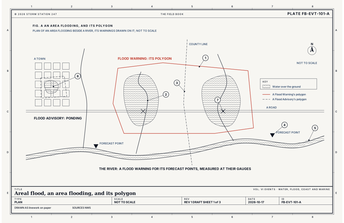
The Weather Service warns it with a Flood Warning drawn on the map as a polygon: an outline around the land where the flooding is expected or reported, which can take in part of one county, several counties, a river basin or a single valley, as Fig. A draws. A warning is issued when flooding over the area is more than 80 percent likely, or is reported over a wide area, and a warning for a river's forecast points cannot measure it. Water that calls for less than a warning, a stream running high or water ponding in low spots, is given a Flood Advisory instead.
What it is not
It is not a flash flood. Water that rises fast, generally within 6 hours of its cause, in a small steep basin, a city street or below a failed dam, is a flash flood with its own warning, Flash flood FB-EVT-100. An areal flood comes more slowly and stays longer.
It is not a river flood at a forecast point. A river with a gauge, a flood stage and a forecast crest is warned point by point, River flood FB-EVT-102. The two products share the name Flood Warning, and the code line at the head of each tells them apart: FA for an area, FL for a river point. Fig. B sets them side by side. Each alert on this site leads to the plate its own code names.
It is not, in its smallest form, a separate thing from urban flooding. Water ponding where drains cannot keep up is most often an Urban and Small Stream Flood Advisory, Urban and poor drainage flood FB-EVT-103. This plate is the flooding of a wider area.
Lookalikes
- Flash flood
- Water that rises fast, generally within 6 hours of its cause, in a small steep basin or a city, with its own warning, Flash flood FB-EVT-100. An areal flood comes more slowly and stays longer.
- River flood
- A flood at a point on a river, with a gauge, a flood stage and a forecast crest, warned by a Flood Warning for forecast points, River flood FB-EVT-102. The two share the name Flood Warning, and its code tells them apart: FL for a river point, FA for an area.
- Urban and poor drainage flood
- Water ponding where drains cannot keep up, most often an Urban and Small Stream Flood Advisory, Urban and poor drainage flood FB-EVT-103. This plate is the flooding of a wider area, and its warning.
Machine
Rain the ground cannot take
Rain that falls on the ground either soaks in, is held on leaves and in hollows, or runs off. Runoff is what floods. How much of the rain runs off depends less on the rain than on the ground: what the soil is, what covers it, and how wet it already is. The equation below, the runoff curve number, gives the share for a small area. A curve number near 100 is pavement, where almost everything runs off; lower numbers are woods and deep soils, which take in most of what falls.
The same rain, twice
Fig. C draws the same 3 in (76 mm) of rain on the same ground twice. Dry, at curve number 70, the first 0.86 in (22 mm) all soaks in before any water moves, and in the end 0.71 in (18 mm) runs off. Soaked by the rain of the days before, its number is 84: the first 0.38 in (10 mm) soaks in, and 1.52 in (39 mm) runs off, 2.12 times as much. This is why a second storm floods ground the first one did not, and why the same forecast rain can bring a Flood Watch after a wet week and none after a dry one: the watch weighs the soil as well as the rain.
Where the water goes
Water that runs off follows the ground downhill to the nearest ditch or small stream. Small streams rise within hours, and where they meet low, flat ground they spread into the fields beside them. In towns, paving and roofs shed almost all the rain, and storm drains carry only so much before water backs up into the streets. Frozen ground takes in little, much like pavement, which is why rain on snow over frozen soil floods so readily in late winter, adding the melt to the rain.
Other causes
A Flood Warning names its cause in its code. Most often it is excessive rainfall. It can also be snowmelt, rain and snowmelt together, an ice jam that backs a stream up over the land behind it, the release of water from a dam or reservoir upstream, or the failure of a dam or a levee.
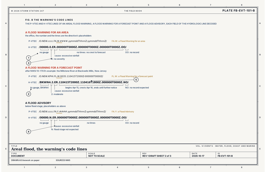
- No gauge: 00000
- The gauge of a forecast point
- Severity, 0 for an area
- The cause: ER, excessive rainfall
- The times of a river point's flood
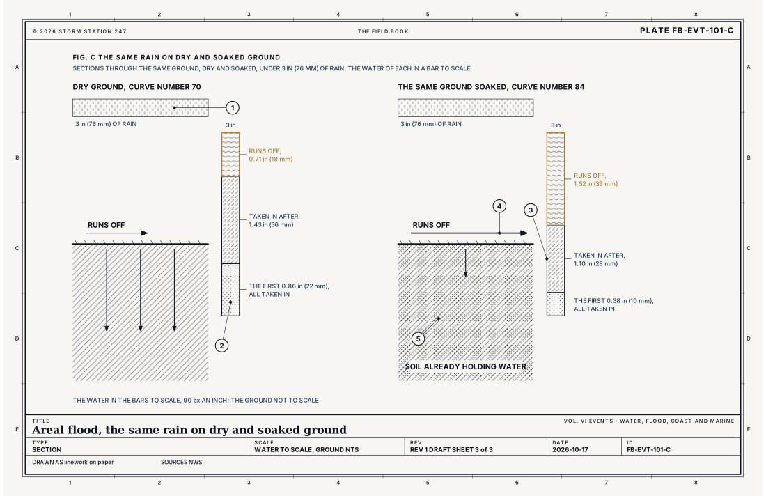
- The rain, 3 in (76 mm)
- The first rain, all taken in
- Taken in after the water begins to run off
- Runs off: 0.71 in (18 mm) dry, 1.52 in (39 mm) soaked
- Soil already holding water
Ingredients
- Rain for many hours, or rain on rain, over ground already wet
- Ground that takes in little: soaked, frozen, paved or clay
- Snow melting, with rain or without it
- Low, flat ground and small streams that drain slowly
Scales
- time
- hours to days, from the rain to the water draining away
- horizontal
- part of one county to several counties, inside a polygon
- vertical
- inches to a few feet of water over the ground
- orlanski
- meso-gamma to meso-beta
Equations
The runoff curve number
- the rain that runs off, in
- the rain that falls, in
- the most water the ground could still take in, in
- the curve number, 0 to 100, set by the soil, what covers it and how wet it already is
Assumes Rain falling over a small area, in inches. Nothing runs off until the first 0.2 S has been taken in, so the equation holds for P greater than 0.2 S. The curve number for wet ground is higher than for the same ground at its usual wetness, by the textbook's relation CN for wet ground = 23 CN / (10 + 0.13 CN).
Working form Three inches (76 mm) of rain on ground of curve number 70: S = 4.29 in, the first 0.86 in (22 mm) is all taken in, and 0.71 in (18 mm) runs off. The same ground soaked, its number 84: S = 1.90 in, the first 0.38 in (10 mm) is taken in, and 1.52 in (39 mm) runs off, 2.12 times as much.
Signatures
- surface
- rain gauges with several inches over a day or two; streams and ditches rising; reports of roads closed and fields under water
- radar
- rain over the same area for many hours; the totals the radar estimates large over a wide area
- satellite
- a slow storm or a stalled front; the cloud staying over the same ground
- sounding
- deep moisture through the column; the air holding much more water than usual
Numbers
| Quantity | Value, and the kind of number it is |
|---|---|
| Flood Warning | Flooding over an area more than 80 percent likely, or reported over a wide area, where a warning for forecast points cannot measure itStandard, Directive 10-922 |
| The polygon | All or part of one or more counties, a river basin, or any other definable area such as a valley; never widened, so flooding beside it is given a new warningStandard, Directive 10-922 |
| Flood Advisory | Elevated streamflow or ponding of water, occurring or more than 80 percent likely, calling for notice less urgent than a warningStandard, Directive 10-922 |
| Kinds of Flood Advisory | Urban and Small Stream, Arroyo and Small Stream, Small Stream, Flood, and HydrologicStandard, Directive 10-922 |
| Flood Watch | Flooding about 50 to 80 percent likely within 48 hours, or a dam or levee that may fail with the threat not yet imminent; coded FA when the cause is rainStandard, Directive 10-922 |
| How long a warning runs | Until the flooding is expected to end; extended in time by a new issuance, ended by a Flood StatementStandard, Directive 10-922 |
| Causes an areal Flood Warning names | ER excessive rainfall, SM snowmelt, RS rain and snowmelt, IJ ice jam, IC rain, snowmelt or ice jam, DM dam or levee failure, DR upstream dam or reservoir release, GO glacier dammed lake outburst, MC other multiple causes, UU unknownStandard, Directive 10-922 |
| The hydrologic code line of an area | /00000.0.ic.000000T0000Z.000000T0000Z.000000T0000Z.OO/: no gauge, no severity, no times and no record; only the causeStandard, Directive 10-1703 |
| Severity N | A Flood Advisory's code: flood stage is not expected to be metStandard, Directive 10-1703 |
| Runoff from 3 in (76 mm) of rain | 0.71 in (18 mm) on ground of curve number 70; 1.52 in (39 mm) on the same ground soaked, number 84Textbook, Chow 1988 |
| Moving water that knocks an adult down | 6 in (15 cm)Standard, Turn Around Don't Drown |
| Moving water that carries away a small car | 12 in (30 cm)Standard, Turn Around Don't Drown |
How the station sees it
No single instrument sees an areal flood, which is why it has no forecast point. The rain is measured by the airport weather stations hour by hour and by the volunteer rain gauges each morning, and the radar on the live map estimates the rain over every square mile in between. The small streams that have a gauge report their stage as often as every 15 minutes. Most of what the office knows about the water on the ground comes from reports: roads closed, fields under water, streams out of their banks.
Severe Alerts on this site shows every Flood Warning and Flood Advisory in force, each with its own report, the office's own words and the counties it covers.
- Volunteer rain gauges: the rain over the area, measured each morning
- Airport weather stations: the rain, hour by hour
- River and lake gauges: the small streams that have a gauge, as often as every 15 minutes
- Severe Alerts: every Flood Warning and Flood Advisory in force, each with its own report
How it is warned
A Flood Watch is issued when flooding over an area is about 50 to 80 percent likely within the next 48 hours, or when a dam or levee may fail and the threat is not yet imminent. Its code is FA when the cause is rain, the common case.
A Flood Warning is issued when flooding over the area is more than 80 percent likely, or is reported over a wide area. Its polygon cannot be widened once it is issued, so flooding that spreads to the land beside it is given a new warning of its own. It runs until the flooding is expected to end. It can be extended in time, and a Flood Statement ends it when the water goes down.
A Flood Advisory is issued for a stream running high or water ponding, occurring or more than 80 percent likely, that calls for notice less urgent than a warning. It comes in kinds: an Urban and Small Stream Flood Advisory, an Arroyo and Small Stream Flood Advisory in the dry Southwest, a Small Stream Flood Advisory, a Flood Advisory, and a Hydrologic Advisory.
Do not drive into water over a road. Moving water 6 in (15 cm) deep can knock an adult down, and 12 in (30 cm) can carry away a small car. Water hides a road that has washed out beneath it. Turn around, don't drown.
| VTEC | Phenomenon | The alerts that carry it |
|---|---|---|
FA | areal flood | Flood Advisory; Flood Statement; Flood Warning; Flood Watch |
Weather radio (SAME) codes: FLA FLW FLS
See also
- Flash flood FB-EVT-100
- River flood FB-EVT-102
- Urban and poor drainage flood FB-EVT-103
- Heavy rain and training storms FB-EVT-022
- The hydrologic cycle FB-WAT-030
- Melt and runoff FB-WAT-032
- How to read a warning FB-STN-001
- Watch, warning and advisory FB-STN-004
Sources
- National Weather Service. Directive 10-922, Weather Forecast Office Hydrologic Products Specification.
- National Weather Service. Directive 10-1703, Valid Time Event Code (VTEC).
- National Weather Service. Manual 10-950, Definitions and General Terminology.
- National Weather Service. Flood Related Hazards.
- National Weather Service. Turn Around Don't Drown.
- Chow, V. T., D. R. Maidment and L. W. Mays. Applied Hydrology (1988).
Definition after the Directive 10-922, Weather Forecast Office Hydrologic Products Specification. Plate FB-EVT-101, revision 1, 2026-10-17. The number is permanent; cite it.