What it is
A supercell is a thunderstorm whose updraft rotates, deeply and for a long time. The rotating updraft is called the mesocyclone. It is 2 to 10 km (1 to 6 mi) across, it spins at least a few kilometres deep, and it lasts tens of minutes or hours rather than the few minutes an ordinary cell's eddies do.
The rotation is not decoration. It is what organizes the storm. An ordinary cell rains into its own updraft and dies in half an hour. A supercell's rotation and the pressure it lowers keep drawing warm, moist air up through the same column, while its rain and hail fall to one side. The storm becomes steady: one updraft, one engine, running for hours and moving across a hundred kilometres or more.
That steadiness is why supercells make most of the largest hail, much of the damaging wind, and nearly all of the strongest tornadoes.
What it is not
It is not a tornado. A tornado is a small vortex, tens to hundreds of metres across, beneath some supercells some of the time. In one national study about a quarter of the mesocyclones radar detected were tornadic; the rest were not. Mesocyclone strength is not tornado strength.
It is not any storm with a hook on radar, or any rotating cloud. Rotation along a squall line, the mesovortex of a line of storms, is shallower and shorter lived, and makes tornadoes by a different path. A wall cloud marks the base of an updraft; it rotates under a supercell, but it can appear without one.
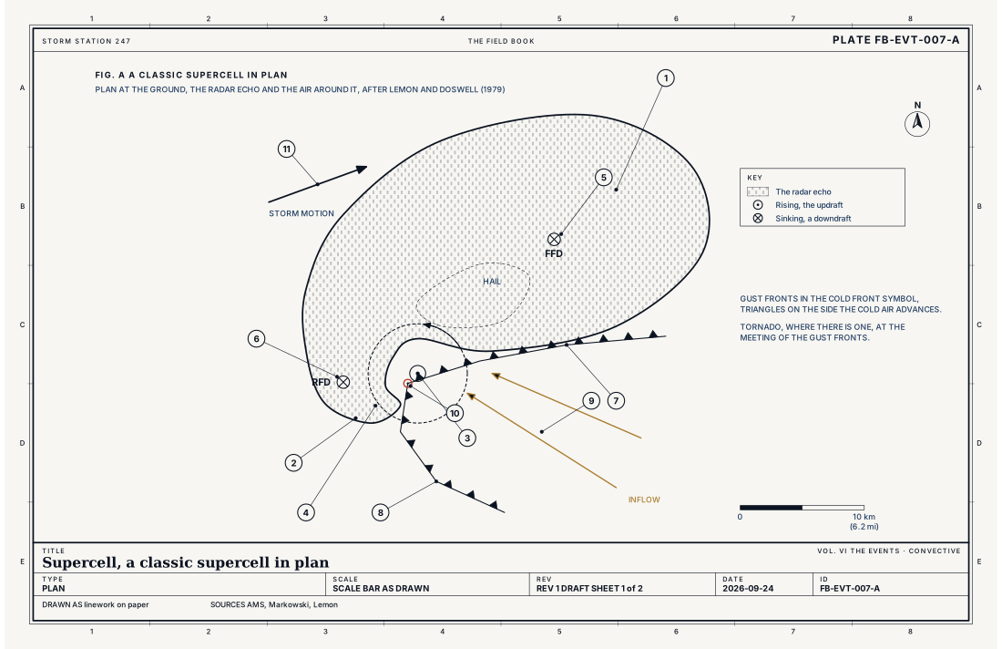
It is not only one kind of storm. Forecasters sort supercells by how much rain falls near the updraft: the classic supercell drawn in Fig. A; the high precipitation supercell, whose rain wraps around the rotation and hides it; and the low precipitation supercell, whose updraft stands nearly bare in dry air, with little rain and often large hail.
Lookalikes
- Multicell storm
- Many cells, each living half an hour, the storm renewing itself along its gust front. It can be severe, and it has no deep persistent rotation. That is Multicell cluster FB-EVT-003.
- Wall cloud
- A lowering beneath the updraft base. It marks where the updraft is; not every one rotates, and a rotating one is not a tornado. That is Wall cloud FB-SKY-040.
- QLCS mesovortex
- Rotation along a squall line, shallower and shorter lived, which makes tornadoes by a different path. That is QLCS tornado FB-EVT-019.
The machine
The rotation comes from the wind before the storm exists.
- The environment spins horizontally. When the wind strengthens and turns with height, the lowest kilometres of air hold horizontal vorticity: spin about a horizontal axis, like a rolling pin laid on the ground. Fig. B draws the hodograph that says how much, and in which direction.
- The updraft tilts the spin upright. A storm's updraft rising through that air lifts the rolling pin in the middle into an arch. The arch has two legs, one spinning each way. When the inflow's spin points along the direction the air is flowing into the storm (streamwise vorticity), the updraft and the cyclonic leg coincide: the updraft itself rotates. That is tilting, the first term of the vorticity equation given below.
- The updraft stretches it. Where the updraft accelerates upward, the rotating column is stretched and narrows, and spins faster, as a skater does pulling in their arms. That is stretching, the second term.
- The rotation lowers the pressure. A spinning column has low pressure at its centre. Where the rotation is strongest, in the middle levels, the low pressure pulls air upward from below. The storm's rotation and its updraft now feed each other, and the updraft grows stronger than buoyancy alone would make it.
- The storm turns right. In the usual hodograph, curving clockwise with height, the new updraft is favoured on the right flank of the storm, and the storm moves to the right of the mean wind, across the shear, by about 7.5 m s⁻¹ (17 mph). Moving across the wind, it takes in more of the spinning inflow. That right mover is the storm drawn in Fig. A.
- The downdrafts separate. Rain and hail fall to the north and east of the updraft, dragged down in the forward flank downdraft. Air descending behind the updraft, the rear flank downdraft, wraps around its south side. Their gust fronts spread along the ground and meet at the point where the hook echo curls.
- A tornado is a separate step. Near the ground, the mesocyclone may be joined by rotation made along the downdrafts' cold edges, and stretched beneath the updraft into a tornado. Whether that happens depends on details of the downdrafts' temperature and the lowest hundreds of metres of wind that are still an active area of research. The Book treats it on its own plate, Tornado FB-EVT-009.
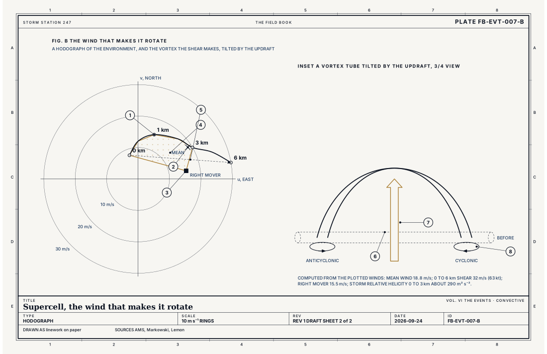
- The hodograph, 0 to 6 km
- The mean wind, 0 to 6 km
- The right mover's motion
- The storm relative helicity, 0 to 3 km, as area
- The deep shear, 0 to 6 km
- A vortex tube in the inflow
- The updraft tilting it
- The two legs, cyclonic and anticyclonic
Ingredients
- Buoyancy: moderate to large CAPE, commonly 1,000 J kg⁻¹ or more
- Deep shear: the wind changing by about 20 m s⁻¹ (40 kt) or more between the ground and 6 km
- Low level shear, turning with height: horizontal vorticity the inflow carries into the updraft, measured as storm relative helicity
- Moisture in the lowest kilometre or two
- A lifting mechanism, and often a cap that holds convection back until the few storms that break it have the air to themselves
Scales
- time
- 1 to 4 hours, some longer
- horizontal
- the storm 10 to 50 km (6 to 30 mi); its mesocyclone 2 to 10 km (1 to 6 mi)
- vertical
- the troposphere, with an overshooting top above the tropopause
- orlanski
- meso-gamma to meso-beta
Equations
Vertical vorticity, tilting and stretching
- vertical vorticity, the spin about a vertical axis, s⁻¹
- horizontal vorticity, the spin the shear gives the inflow, s⁻¹
- vertical velocity, m s⁻¹
- how the vertical velocity changes across the horizontal
Assumes The earth's rotation, friction and the baroclinic (solenoidal) term are left out; for the midlevel mesocyclone they are small beside tilting and stretching.
Storm relative helicity
- the environmental wind at height z
- the storm's motion
- the top of the inflow layer, commonly 1 or 3 km
- the unit vector pointing up
Assumes A steady storm moving at c through an environment that does not change. On a hodograph it is minus twice the area swept between the storm motion and the hodograph from the ground to h.
Working form Units are m² s⁻²; values above about 150 for 0 to 3 km favour supercells that rotate strongly at low levels.
Signatures
- sounding
- large CAPE; strong deep shear; a long hodograph curving clockwise in the lowest kilometres; a cap
- radar
- a hook or pendant at the rear of the echo; a bounded weak echo region over the inflow, where the updraft is too strong for rain to form; a mesocyclone: a couplet of inbound and outbound velocity, 2 to 10 km across; a column of high differential reflectivity above the freezing level, the updraft carrying liquid drops upward; a tornado debris signature when a tornado lofts debris
- satellite
- an overshooting top; an above anvil cirrus plume; an anvil spreading against the upper wind
- surface
- an inflow of warm moist air from the southeast; a rear flank gust front; pressure falls ahead of the storm
The numbers
| Quantity | Value, and the kind of number it is |
|---|---|
| Definition | A thunderstorm with a deep, persistent mesocycloneStandard, Glossary of Meteorology |
| Mesocyclone | 2 to 10 km (1 to 6 mi) across; vertical vorticity about 0.01 s⁻¹ or more, over a depth of several kilometres, lasting tens of minutesTextbook, Markowski 2010 |
| Updraft | 25 to 50 m s⁻¹ (56 to 112 mph) or moreTypical, Markowski 2010 |
| Deep shear | 0 to 6 km bulk shear of about 20 m s⁻¹ (40 kt) or moreTypical, Markowski 2010 |
| Storm motion | A right moving supercell travels about 7.5 m s⁻¹ (17 mph) to the right of the mean wind, across the shearTextbook, Bunkers 2000 |
| Tornadic | About a quarter of the mesocyclones detected by radar in one national study were tornadicTextbook, Trapp 2005 |
| Life | 1 to 4 hours, some longerTypical, Markowski 2010 |
| Severe | Hail 2.5 cm (1 in) across or larger, a gust of 26 m s⁻¹ (58 mph) or more, or a tornadoStandard, Directive 10-511 |
How the station sees it
The radar sees the structure. In reflectivity, the hook at the rear of the echo, a notch where the inflow enters, and above the notch a bounded weak echo region: a vault where the updraft rises too fast for rain to form in it. In velocity, the mesocyclone is a couplet of wind toward and away from the radar, side by side, a few kilometres apart. Dual polarization adds a column of large liquid drops carried above the freezing level by the updraft, and, when a tornado lofts debris, a signature of objects that are not rain.
The airport weather stations see the storm's edges. Ahead of it, pressure falls and warm, moist inflow blows toward the storm. As the forward flank gust front passes, the wind turns and the temperature drops; the rear flank gust front brings a sharper shift, and sometimes the strongest wind of the storm.
The satellite sees the top: an overshooting dome above the anvil over the updraft, and a plume of cirrus above the anvil downwind of it.
- The radar on the live map: the rain and hail, the hook and the notch, every few minutes
- Airport weather stations: the inflow, the pressure falls, and the gust fronts as they pass
- Road weather stations: wind and visibility where the storm crosses the highways
How it is warned
Supercells are forecast before they form. When the ingredients are present over a region, a Tornado Watch or a Severe Thunderstorm Watch is issued for several hours. When a supercell is producing severe hail or wind, a Severe Thunderstorm Warning is issued, drawn as a polygon around the storm's path. When its rotation indicates a tornado, or one is observed, a Tornado Warning is issued. Its text says which: SOURCE...radar indicated rotation, or SOURCE...confirmed tornado.
A warning for a supercell is a warning for a storm that will keep coming. It moves at 10 to 20 m s⁻¹ (22 to 45 mph) and it does not weaken on a schedule. Shelter in an interior room on the lowest floor, away from windows, before it arrives.
| VTEC | Phenomenon | The alerts that carry it |
|---|---|---|
SV | severe thunderstorm | Severe Thunderstorm Warning; Severe Thunderstorm Watch |
TO | tornado | Tornado Warning; Tornado Watch |
Weather radio (SAME) codes: SVA SVR SVS TOA TOR
See also
- Thunderstorm FB-EVT-001
- Mesocyclone FB-EVT-008
- Tornado FB-EVT-009
- Hailstorm FB-EVT-015
- Cumulonimbus architecture FB-SKY-041
- CAPE, CIN and the sounding FB-ENG-006
- Vorticity and stretching FB-ENG-010
- WSR-88D radar FB-INS-005
- Dual polarization radar products FB-INS-010
- How to read a warning FB-STN-001
Sources
- American Meteorological Society. Glossary of Meteorology.
- Markowski, P. and Y. Richardson. Mesoscale Meteorology in Midlatitudes (2010).
- Lemon, L. R. and C. A. Doswell III. Severe Thunderstorm Evolution and Mesocyclone Structure as Related to Tornadogenesis, Monthly Weather Review 107 (1979).
- Bunkers, M. J. and others. Predicting Supercell Motion Using a New Hodograph Technique, Weather and Forecasting 15 (2000).
- Trapp, R. J., G. J. Stumpf and K. L. Manross. A Reassessment of the Percentage of Tornadic Mesocyclones, Weather and Forecasting 20 (2005).
- National Weather Service. Directive 10-511, WFO Severe Weather Products Specification.
Definition after the Glossary of Meteorology. Plate FB-EVT-007, revision 1, 2026-09-24. The number is permanent; cite it.