What it is
A flash flood is a flood that rises within six hours of what causes it. That is the Weather Service's definition, and the six hours are the point: a river flood can be seen coming for days, and a flash flood cannot. In a steep canyon the rise can come minutes after the rain, as a wall of water from a storm the people in its path never saw.
The cause is almost always rain falling faster than the ground can take it in, over one basin, for long enough to fill the channel. It can also be water released at once: a dam or a levee that fails, or an ice jam that breaks. Rain is the case this plate draws.
It is one of the leading causes of weather deaths in the United States, and it kills in a particular way. Over half of the people who drown in floods drown in vehicles, driven into water across a road. The next largest share walk into it.
What it is not
It is not a river flood. A river flood is a large basin arriving: rain gathered over thousands of square kilometres, a crest that travels downstream over days, forecast gauge by gauge. The same storm can cause both, the flash flood in the creeks tonight and the river flood downstream next week. Fig. B draws the two from one storm.
It is not the same as water ponding in streets where drains are overwhelmed, though a city can have both at once. Poor drainage flooding is usually an advisory; a flash flood is a warning, because it moves and it kills.
It is not caused only by rain where the flood is. The storm can be kilometres upstream, out of sight, under a clear sky. Slot canyons and desert washes flood this way.
Lookalikes
- River flood
- The same water arriving slowly. A large basin gathers rain over days, and the crest travels downstream, forecast gauge by gauge. That is River flood FB-EVT-102.
- Urban and poor drainage flooding
- Water ponding where drains cannot keep up. It can be sudden, and it is often an advisory, not a warning. That is Urban and poor drainage flood FB-EVT-103.
- Debris flow
- A slurry of mud and rock, most often from a burn scar, which a flash flood can become and which hits far harder than water. That is Debris flow and burn scar flood FB-EVT-104.
The machine
A basin is a funnel. Rain falls on all of it, and runs to one outlet. How much of it runs off, and how fast, decides whether the stream floods.
- Rain falls faster than it soaks in. Every surface takes in water at some rate. Loose, dry soil under grass takes in a good deal. Pavement and roofs take in none. Soil that is already full, or baked hard, or burned, takes in little. What is not taken in runs off.
- The runoff gathers. Sheets of water become rills, rills become gullies, gullies become the creek. The time for water to travel from the far edge of the basin to its outlet is the time of concentration. In a small, steep, paved basin it is minutes. In a large, flat, wooded one it is days.
- The rain must last. When rain falls evenly over the whole basin for at least the time of concentration, all of it is sending water to the outlet at once, and the flow there reaches its peak. That is why a slow storm is so dangerous, and why cells that train, one after another over the same ground, are worse than one strong cell that passes.
- The channel overflows. A creek that carries a trickle is sized by years of ordinary storms. The peak of a flash flood can be many times its usual flow, and the water leaves the channel.
For a small basin, the peak flow can be estimated in one line. The rational method multiplies the rain rate by the basin's area and by the fraction of the rain that runs off. Its assumptions are listed with it below: it is a tool for small basins, not a forecast for a river.
The runoff coefficient is where the land enters. Pavement sends 70 to 95 percent of the rain to the drains. A lawn sends 5 to 35 percent. A city built over a basin raises its coefficient and shortens its time of concentration at once, so the same storm floods it faster and higher than it did the field before. A burn scar does the same thing to a mountainside for a year or more after the fire, until the ground heals.
Why the road kills
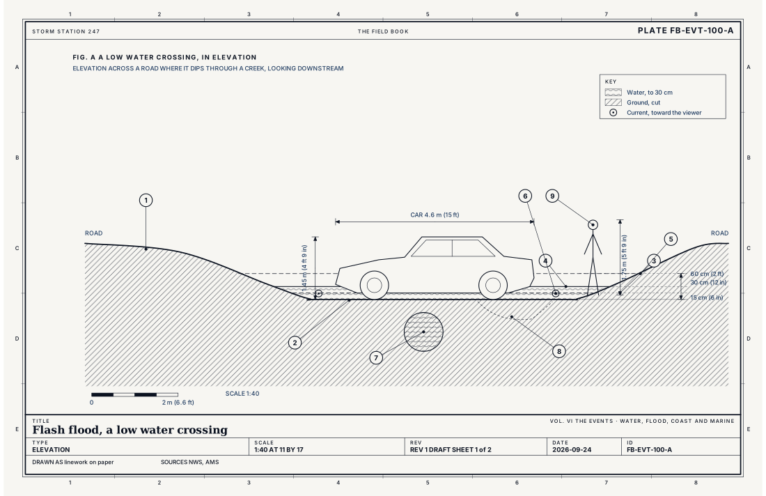
Fig. A draws a low water crossing at one scale, with a car and a person beside it. Water flowing across a road pushes on everything in it, and the push grows with the depth and with the square of the speed. At 15 cm (6 in) of moving water an adult can be knocked down. At 30 cm (12 in) a small car begins to float: the water it displaces lifts it, the tyres lose their grip, and the current does the rest. At 60 cm (2 ft) most vehicles are carried away, trucks and SUVs included. The road under the water cannot be seen, and it may already have been scoured away. The depth cannot be judged from the driver's seat, at night, in rain.
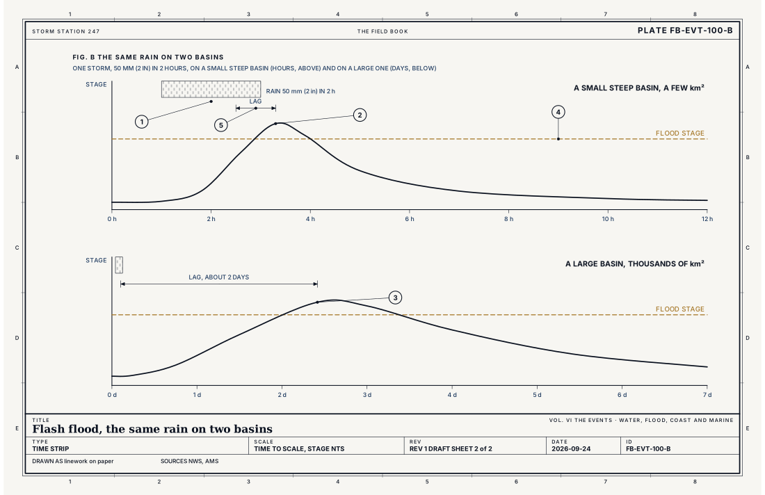
- The rain, 50 mm (2 in) in 2 hours
- A small steep basin, a few km²
- A large basin, thousands of km²
- Flood stage
- The lag, from the heaviest rain to the crest
Ingredients
- Rain faster than the ground can take it in: rates of 25 to 50 mm (1 to 2 in) an hour or more
- Rain that stays over one basin, from a slow storm, or from cells that train, one after another, over the same ground
- A basin that sheds water fast: steep, paved, bare rock, a burn scar, or soil already full
- Or no rain at all: a dam or levee that fails, or an ice jam that breaks
Scales
- time
- minutes to 6 hours from the cause to the rise
- horizontal
- a basin of a few square kilometres to a few hundred (about 1 to 100 mi²)
- vertical
- a rise of 1 to 10 m (3 to 33 ft) in a steep channel, sometimes more
- orlanski
- meso-gamma
Equations
The rational method
- peak discharge at the basin's outlet, m³ s⁻¹
- runoff coefficient, the fraction of the rain that runs off, 0 to 1
- rain rate over the basin, mm h⁻¹, lasting at least the time of concentration
- the basin's area, km²
Assumes A small basin, commonly under about 0.8 km² (200 acres), with rain falling evenly over all of it for at least the time water takes to travel from the far edge to the outlet (the time of concentration). The factor 0.278 converts mm h⁻¹ times km² to m³ s⁻¹.
Working form In U.S. units , with in cubic feet a second, in inches an hour and in acres: the conversion is within 1 percent of one.
Signatures
- sounding
- a deep moist column with high precipitable water; a freezing level high enough that little of the rain is lost to ice; and weak winds aloft that let storms linger
- radar
- rain rates of 25 to 50 mm (1 to 2 in) an hour or more over one basin; echoes that train, one cell after another along the same track; dual polarization rain estimates rising past the basin's flash flood guidance
- satellite
- cold cloud tops that stay over the same place for hours
- surface
- a stream gauge that rises metres in an hour; rain gauges reporting totals in a few hours that match a day's
The numbers
| Quantity | Value, and the kind of number it is |
|---|---|
| Definition | A rise beginning within 6 hours of its causeStandard, Directive 10-922 |
| Moving water that knocks an adult down | 15 cm (6 in)Standard, Turn Around Don't Drown |
| Moving water that carries away a small car | 30 cm (12 in)Standard, Turn Around Don't Drown |
| Moving water that carries away most vehicles | 60 cm (2 ft), trucks and SUVs includedStandard, Turn Around Don't Drown |
| Who dies | Over half of flood drownings are in vehicles driven into flood waterStandard, Turn Around Don't Drown |
| Rain rates that flood | Commonly 25 to 50 mm (1 to 2 in) an hour or more; much less on a burn scar or a basin already wetTypical |
| Runoff coefficient | Pavement and roofs 0.7 to 0.95; lawns 0.05 to 0.35; woods 0.05 to 0.25Textbook, Chow 1988 |
| Flash flood guidance | The rain over 1, 3 or 6 hours that would bring small streams to flood, set for each basin by the River Forecast CentersStandard, Directive 10-922 |
How the station sees it
The station sees the rain first and the water second.
The radar on the live map estimates the rain rate over every basin every few minutes. Dual polarization radar estimates it better than the older radars could, because it can tell large drops from hail. What a forecaster watches is the rain over a basin building toward the flash flood guidance: the amount over one, three or six hours that the River Forecast Center has worked out will bring that basin's small streams to flood.
Volunteer rain gauges, read each morning, measure what actually fell, and airport weather stations report the rate minute by minute. Their totals are how the radar's estimates are checked after the event.
River and stream gauges in the instrument atlas see the water itself: the stage and the flow, many of them every 15 minutes. On a flashy creek the gauge can rise several metres in an hour. It is the most certain sign, and the latest.
- River and stream gauges: the stage and flow of the stream, as often as every 15 minutes
- Volunteer rain gauges: the rain that fell, measured each morning
- Airport weather stations: the rain rate, minute by minute
- The radar on the live map: the rain rate over the whole basin, every few minutes
How it is warned
A Flood Watch or a Flash Flood Watch is issued when heavy rain is expected over an area where it could flood, often a day ahead. A Flash Flood Warning is issued when flash flooding is happening or about to happen; like a thunderstorm warning, it is drawn as a polygon around the threat. A Flash Flood Emergency is issued, rarely, when a flash flood is threatening lives and causing catastrophic damage: people are in danger where they are.
The safety rule is four words long, and it is the whole of it: turn around, don't drown. Do not drive or walk into moving water. Move to higher ground. In a canyon or a wash, climb, and do not wait to see the water.
| VTEC | Phenomenon | The alerts that carry it |
|---|---|---|
FF | flash flood | Flash Flood Statement; Flash Flood Warning; Flash Flood Watch; Flood Watch |
Weather radio (SAME) codes: FFA FFW FFS
See also
- Flash flood from slow moving convection FB-EVT-017
- Heavy rain and training storms FB-EVT-022
- River flood FB-EVT-102
- Urban and poor drainage flood FB-EVT-103
- Debris flow and burn scar flood FB-EVT-104
- Thunderstorm FB-EVT-001
- The hydrologic cycle FB-WAT-030
- WSR-88D radar FB-INS-005
- How to read a warning FB-STN-001
Sources
- National Weather Service. Directive 10-922, Weather Forecast Office Hydrologic Products Specification.
- National Weather Service. Turn Around Don't Drown.
- American Meteorological Society. Glossary of Meteorology.
- Chow, V. T., D. R. Maidment and L. W. Mays. Applied Hydrology (1988).
Definition after the Directive 10-922, Weather Forecast Office Hydrologic Products Specification. Plate FB-EVT-100, revision 1, 2026-09-24. The number is permanent; cite it.