What it is
A waterspout is a tornado over water: a column of air spinning from the surface of the sea or a lake up to the base of a cloud, often marked by a funnel of condensed cloud above and a ring of spray below. There are two kinds. Most are fair weather waterspouts, which grow from the water up under a line of building cumulus on a day of light wind. They are smaller, slower and weaker. A few are tornadic waterspouts: tornadoes from a rotating thunderstorm, larger, faster and stronger, which form over the water or move onto it from land, and bring the storm's high winds, large hail and lightning with them.
Over coastal waters and the Great Lakes, a waterspout is warned by a Special Marine Warning. When one comes ashore, the Weather Service issues a Tornado Warning, because some can do real damage on land.
What it is not
It is not a different thing from a tornado, Tornado FB-EVT-009. The tornadic kind is a tornado, and even the fair weather kind is a spinning column from the surface to the cloud; it is weaker because of how it forms, not because it is over water.
It is not a cold air funnel, Cold air funnel FB-EVT-014: a funnel from the showers of a cool day that seldom reaches the ground or the sea.
It is not what a gale warning warns, Gale, storm and hurricane force marine wind FB-EVT-113. Gale, storm and hurricane force wind warnings forecast winds over whole marine zones for hours. A Special Marine Warning covers a storm's short lived dangers in a polygon, for 2 hours at most.
Lookalikes
- Tornado
- The same spinning column over land, Tornado FB-EVT-009. A tornadic waterspout is a tornado from a rotating thunderstorm that forms over water or moves onto it, and a waterspout that comes ashore is warned as a tornado.
- Cold air funnel
- A funnel from the showers of a cool day, under cold air aloft, that seldom reaches the ground or the sea, Cold air funnel FB-EVT-014.
- Gale and storm warnings
- Winds forecast for whole marine zones over hours, Gale, storm and hurricane force marine wind FB-EVT-113. A Special Marine Warning is for a storm's short lived winds, hail or waterspouts, in a polygon, for 2 hours at most.
Machine
From the water up
A fair weather waterspout starts at the surface. Where the wind is light and the water warm, the heating of islands or a coast sets off a line of cumulus, and the cloud line drifts out over the water where there is less friction. The updrafts under the line pull on the air below. Any spin near the sea surface, from the meeting of two breezes or from the edge of an outflow, is stretched upward by the updraft, and stretching makes it spin faster, as a skater spins faster with arms drawn in. The cloud above must have a flat, smooth base, a sign of a steady updraft. A tornadic waterspout works the other way, from the storm down, and is drawn on the tornado's plate.
Five stages
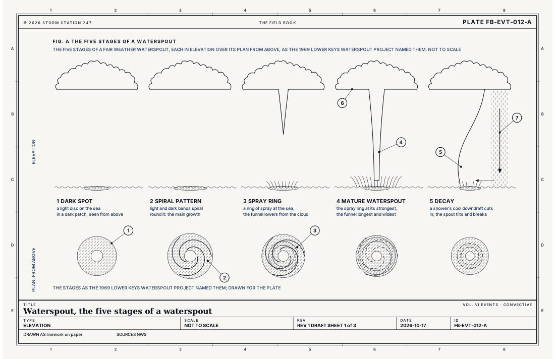
The Lower Keys Waterspout Project of 1969 named the five stages a fair weather waterspout passes through, and Fig. A draws them. First a dark spot: a light disc on the sea surrounded by a dark patch, best seen from above. Then a spiral pattern of light and dark bands winding round it, as the spout grows. Then a spray ring at the sea, while a funnel lowers from the cloud base. At the mature stage the spray ring is at its strongest and the funnel longest and widest. Last, decay: a nearby shower's cool downdraft cuts off the warm, moist air the spout lives on, and it tilts and breaks, often abruptly. Most last 5 to 15 minutes.
Small, and sometimes fierce
Waterspouts in the Florida Keys average 128 ft (39 m) across, from 10 to 345 ft (3 to 105 m). A ring of spray means the wind is above 46 mph (40 knots), enough to endanger a small boat. Over the 1969 project the wind averaged 31 mph (27 knots), the outer wall of three large mature spouts averaged 60 mph (52 knots), and the fastest spinning wind measured was 190 mph (165 knots). Most move at 12 to 17 mph (10 to 15 knots), carried by the wind around their cloud, and some barely move at all.
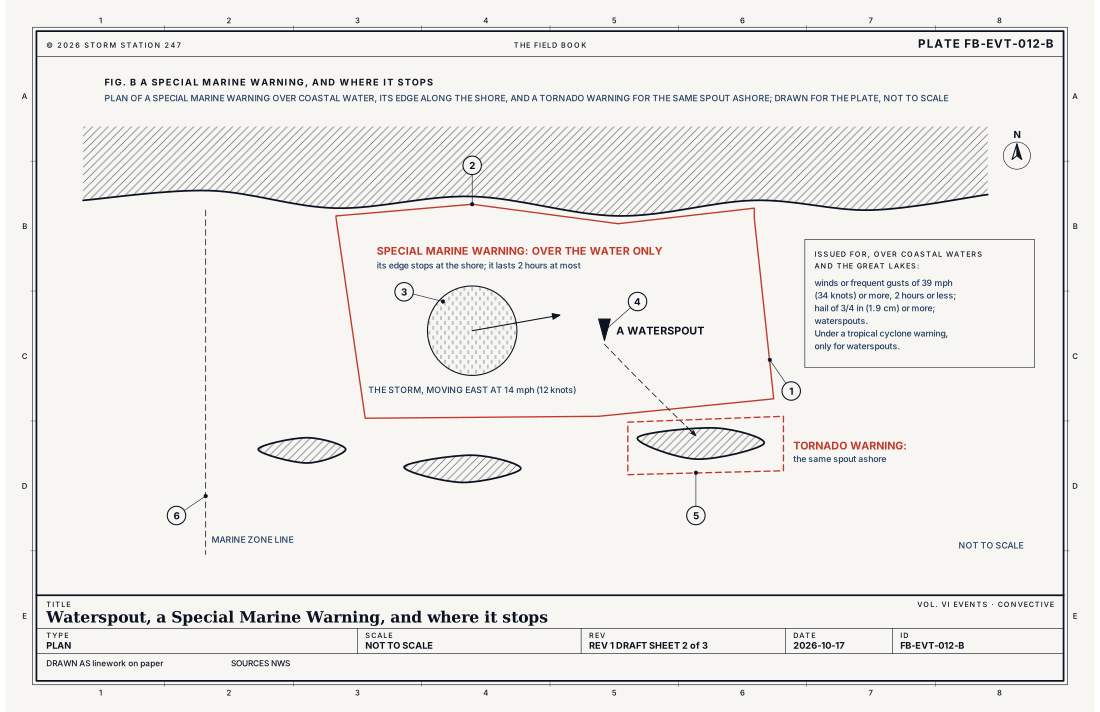
- The Special Marine Warning's polygon
- The shore, where it stops
- The storm, and its motion
- A waterspout
- The Tornado Warning, over the land
- A line between marine zones
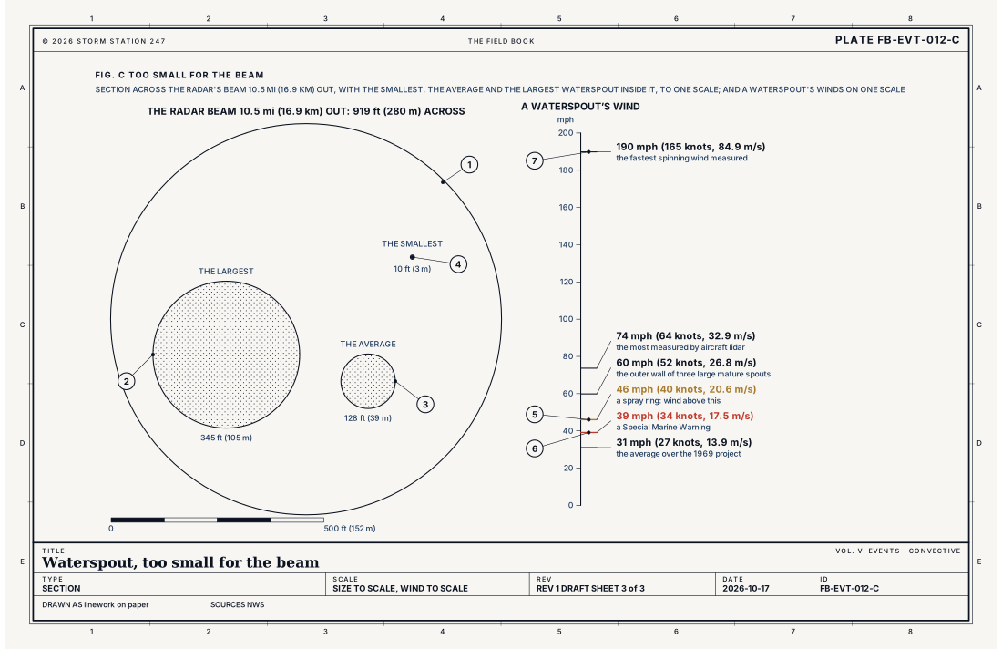
- The radar beam, 919 ft (280 m) across at 10.5 mi (16.9 km)
- The largest waterspout seen, 345 ft (105 m)
- The average, 128 ft (39 m)
- The smallest, 10 ft (3 m)
- The spray ring, wind above 46 mph (40 knots)
- A Special Marine Warning, 39 mph (34 knots)
- The fastest spinning wind measured, 190 mph (165 knots)
Ingredients
- Warm water and warm, moist air over it
- Light wind and little change of wind with height
- A line of building cumulus over the water, its base flat and smooth, often along islands or a coast the sun has heated
- Spin at the sea surface that the cloud's updraft stretches upward; or, for the tornadic kind, a rotating thunderstorm
Scales
- time
- 5 to 15 minutes for most; a fair weather spout often ends abruptly
- horizontal
- 10 to 345 ft (3 to 105 m) across, 128 ft (39 m) on average
- vertical
- from the sea surface to the flat base of its cloud
- orlanski
- micro-gamma to micro-beta
Equations
The width of the radar's beam
- the width of the beam across, ft
- the range from the radar, ft
- the width of the beam as an angle, 0.95 degree, 0.01658 radian
Assumes An angle this small, where the arc and the straight width across are the same; the beam's width taken at its half power edges, as the 0.95 degree is. The radar measures the average of everything inside the beam, so a spinning column much narrower than the beam is smoothed away.
Working form At 10 mi (16.1 km) the beam is 875 ft (267 m) across. At 10.5 mi (16.9 km), 919 ft (280 m), the average width the Key West office gives; at 50 mi (80 km), 4,377 ft (1,334 m). An average waterspout, 128 ft (39 m) across, fills 15 percent of the beam's width at 10 mi, and the largest seen, 345 ft (105 m), 39 percent.
Signatures
- surface
- a dark spot and a spiral on the sea; a ring of spray; reports from boaters; spotters and the coast
- satellite
- lines of cumulus along islands and coasts on a light wind day
- radar
- nothing for most fair weather waterspouts; too narrow for the beam; a rotating storm on the velocity display for the tornadic kind
- sounding
- warm; moist air over warm water; light wind through the column and little shear
Numbers
| Quantity | Value, and the kind of number it is |
|---|---|
| Special Marine Warning | Winds or frequent gusts of 39 mph (34 knots) or more from thunderstorms, lasting 2 hours or less; hail of 3/4 in (1.9 cm) or more; or waterspouts; also short lived gale force winds from no thunderstormStandard, Instruction 10-313 |
| How long it runs | 2 hours at most; a new warning if the danger lasts longerStandard, Instruction 10-313 |
| Where | Coastal waters and the Great Lakes, never any land; not offshore or the high seas, but for designated areas off the East CoastStandard, Instruction 10-313 |
| Under a tropical cyclone warning | Issued only for waterspoutsStandard, Instruction 10-313 |
| A waterspout ashore | A Tornado WarningStandard, Waterspouts |
| The spray ring | Wind above 46 mph (40 knots)Typical, Waterspouts and the Florida Keys |
| Diameter | 128 ft (39 m) on average; 10 to 345 ft (3 to 105 m)Typical, Waterspouts and the Florida Keys |
| Wind | 31 mph (27 knots) on average over the 1969 Lower Keys Waterspout Project; 60 mph (52 knots) at the outer wall of three large mature spouts; 190 mph (165 knots) at mostTypical, Waterspouts and the Florida Keys |
| How long one lasts | 5 to 15 minutes for 70 percent of those reported in the Florida Keys, May 2006 to September 2024Typical, Waterspouts and the Florida Keys |
| How fast one moves | 12 to 17 mph (10 to 15 knots), or nearly still on a day of very light windTypical, Waterspouts and the Florida Keys |
| How many | 20 to 70 a year seen from Key West; more than 1,400 reported to the Key West office from May 2006 to September 2024Typical, Waterspouts and the Florida Keys |
| The radar's beam | 0.95 degree wideStandard, The WSR-88D |
| Getting away | Move at a right angle to its apparent motion; never toward itStandard, Waterspouts |
How the station sees it
The radar on the live map shows the storms over the water and, for a tornadic waterspout, the spin of the storm that makes it. It does not see most fair weather waterspouts. Its beam is 0.95 degree wide, so 10.5 mi (16.9 km) from the radar it is already 919 ft (280 m) across, and the radar reads the average of everything inside it. A spout of 128 ft (39 m) fills 15 percent of that width at 10 mi; its spin is smoothed away. Fig. C draws the beam and three waterspouts to one scale.
So waterspouts are found by eye: by boaters, by spotters on the shore and by the forecasters at the coast, who ask for reports. In the Florida Keys, 20 to 70 are seen from Key West each year, most from May to September and most between noon and 8 pm, and more than 1,400 were reported to the Key West office from May 2006 to September 2024.
- The radar on the live map: the storms over the water, and a rotating storm's spin; most fair weather waterspouts are too narrow for it
- Severe Alerts: every Special Marine Warning in force, each with its own report
How it is warned
A Special Marine Warning is issued for coastal waters and the Great Lakes when a storm brings winds or frequent gusts of 39 mph (34 knots) or more lasting 2 hours or less, hail of 3/4 in (1.9 cm) or more, or waterspouts. It is also issued for short lived gale force winds from no thunderstorm. It is drawn as a polygon over the water and never takes in any land, as Fig. B draws, and it runs for 2 hours at most; a new one follows if the danger goes on. When a tropical cyclone warning is in force, a Special Marine Warning is issued only for waterspouts. Severe Alerts on this site shows each one in force with its own report.
If you see a waterspout from a boat, move away at a right angle to the way it is moving, and never toward it to look. Never try to steer through one. On shore, a waterspout coming toward land is a tornado: go inside, to the lowest floor, away from windows.
| VTEC | Phenomenon | The alerts that carry it |
|---|---|---|
MA | marine | Special Marine Warning |
Weather radio (SAME) codes: SMW
See also
- Tornado FB-EVT-009
- Cold air funnel FB-EVT-014
- Gale, storm and hurricane force marine wind FB-EVT-113
- WSR-88D radar FB-INS-005
- How to read a warning FB-STN-001
Sources
- National Weather Service. Waterspouts and the Florida Keys, the Key West office.
- National Weather Service. Waterspouts, the Miami office.
- National Weather Service. Instruction 10-313, Special Marine Warnings.
- NOAA Radar Operations Center. The WSR-88D, system description and operations.
Definition after the Waterspouts and the Florida Keys, the Key West office. Plate FB-EVT-012, revision 1, 2026-10-17. The number is permanent; cite it.