What it is
A snow squall is a short, intense burst of heavy snow and gusty wind. It comes on in moments, drops the visibility to near zero, and at one place usually passes in 30 to 60 minutes. Snow squalls often come with strong cold fronts, and the temperature can fall sharply as they arrive, so a road wet with melting snow can freeze in a few minutes. A squall can come where no large winter storm is under way, and it often leaves an inch (2.5 cm) of snow or less. It is the suddenness that makes it dangerous: a driver at highway speed goes from a clear road into a whiteout on ice, and there is a long history of deadly crashes in snow squalls.
The Weather Service warns it with a Snow Squall Warning, issued for intense but short periods of moderate to heavy snow with gusty wind that cut the visibility to a whiteout. It is a short warning for the ground in the squall's path, like a Tornado or Severe Thunderstorm Warning, and it runs for 30 to 60 minutes.
What it is not
It is not lake effect snow, Lake effect snow FB-EVT-082: bands off a lake that can hold over the same towns for a day or more. A squall passes.
It is not a blizzard, Blizzard FB-EVT-081, which needs the wind and the low visibility to last three hours or longer, nor a winter storm, Winter storm FB-EVT-080, snow for hours or days from a large storm system. A Snow Squall Warning is never issued while either of those warnings is in force; it can be issued during a Winter Weather Advisory, when conditions are about to turn much worse for a short time.
Lookalikes
- Lake effect snow
- Bands off a lake that can hold over the same ground for days, Lake effect snow FB-EVT-082. A squall passes one place in under an hour.
- Blizzard
- Wind and snow cutting the visibility under a quarter mile for three hours or longer, Blizzard FB-EVT-081. No Snow Squall Warning is issued during a Blizzard Warning.
- Winter storm
- Snow for hours or days from a large storm system, Winter storm FB-EVT-080. No Snow Squall Warning is issued during a Winter Storm Warning.
Machine
A burst along a front
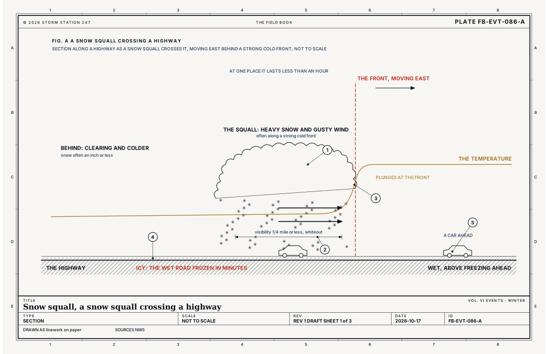
Behind a strong cold front, the air is colder and often unstable near the ground. Where the front lifts it, the air rises quickly into a shallow, narrow line of convective snow cloud, and the snow falls in a heavy burst along the front's leading edge. The wind gusts as the front passes, driving the snow and lifting what lies on the ground, and the visibility falls to a quarter mile or less, often to almost nothing. Fig. A draws it.
The flash freeze
Ahead of the front the air may be above freezing and the roads wet. As the front passes, the temperature plunges. The water on the road, and the snow that melts as it lands, freezes in minutes: a flash freeze. A driver who entered the squall on a wet road leaves it on ice. This is the second of the warning's two conditions: temperatures falling fast enough to flash freeze the roads, together with a sharp drop in the visibility.
Fast, and moving
A squall line moves with its front, often quickly. At one place it lasts less than an hour, but the line itself moves on, across one county after another, so the warning must move with it. The equation below gives the ground a squall crosses while a warning runs: the Weather Service's sample squall, moving east at 40 mph, crosses 33.3 mi (53.6 km) in its warning's 50 minutes. Fig. B draws it.
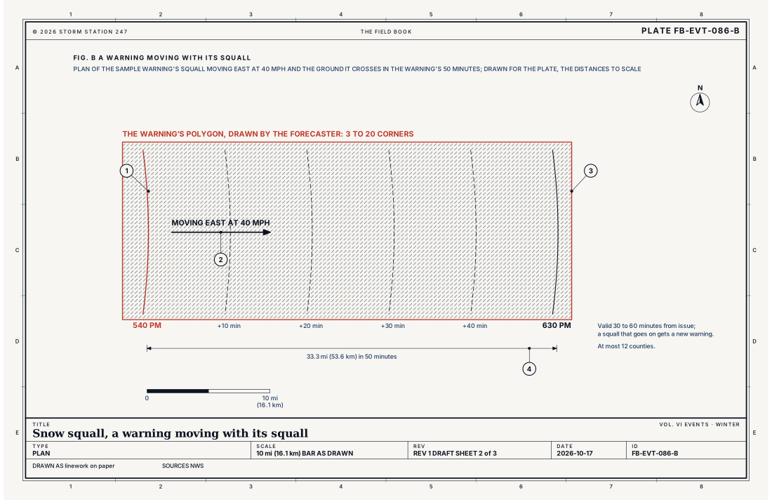
- The squall at 5:40 pm
- Its motion, east at 40 mph (17.9 m/s)
- The polygon, reaching past where the squall will be at 6:30 pm
- 33.3 mi (53.6 km) in 50 minutes
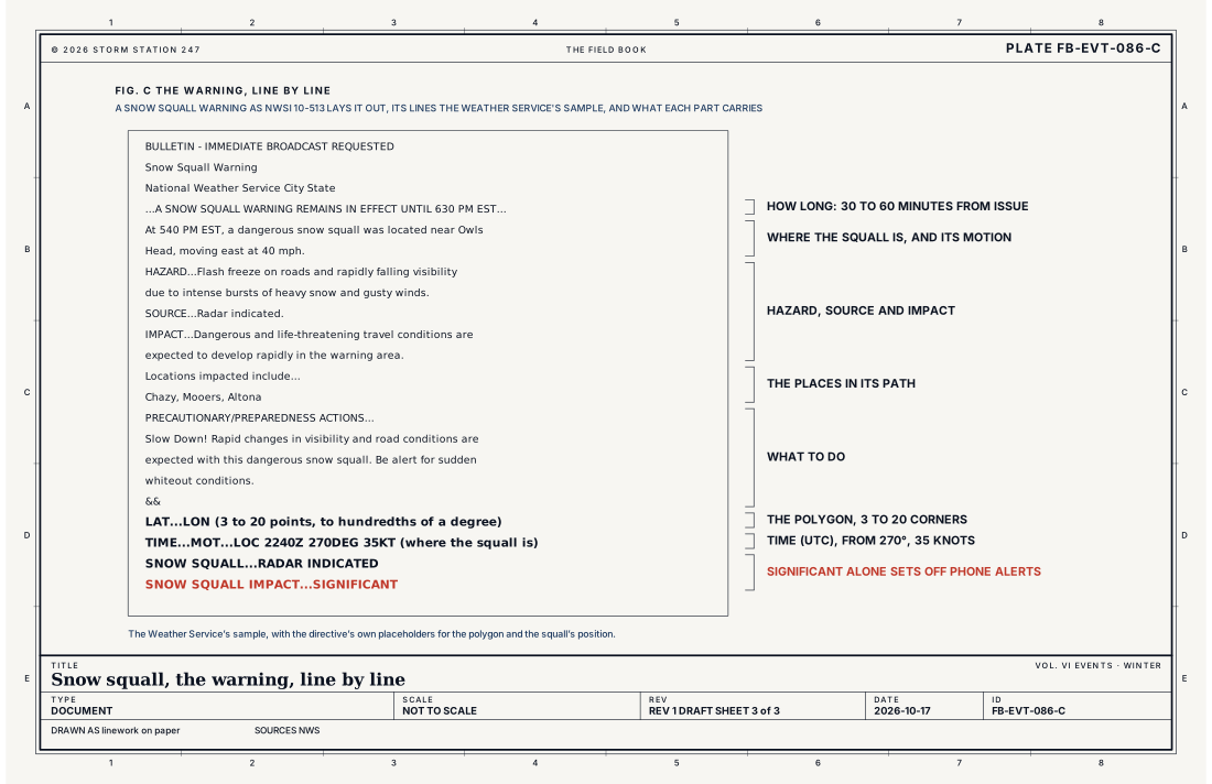
- How long it runs
- Where the squall is, and its motion
- Hazard, source and impact
- The places in its path
- What to do
- The polygon
- The motion line
- The tags
Ingredients
- A strong cold front, or a sharp burst of convective snow
- Gusty wind to drive the snow and blow it about
- A sharp drop in temperature, which can freeze wet roads in minutes
- Roads at or below freezing
Scales
- time
- usually 30 to 60 minutes at one place; the line itself can last for hours as it moves
- horizontal
- a narrow band of heavy snow, often along a cold front, sweeping across a region
- vertical
- a shallow layer of convective snow cloud
- orlanski
- meso-beta to meso-gamma
Equations
The ground a squall crosses
- the distance the squall moves, mi
- its speed, mph
- the time, hours
Assumes The squall moves at a steady speed in a straight line, as a warning's motion line assumes. The warning's polygon must reach as far as the squall will move before the warning ends.
Working form The squall of the Weather Service's sample warning, moving east at 40 mph (17.9 m/s) with 50 minutes to run, crosses 33.3 mi (53.6 km) before the warning ends. A driver at 65 mph (29.1 m/s) covers a quarter mile, the visibility of the warning's first condition, in 13.8 seconds.
Signatures
- surface
- the visibility falling to a quarter mile or less within minutes; the wind gusting; the temperature dropping sharply as the front passes
- satellite
- a narrow line of cloud along the front; clearing behind it
- radar
- a narrow; fast-moving line or burst of snow echo
- sounding
- cold air behind the front; unstable enough near the ground for convective snow
Numbers
| Quantity | Value, and the kind of number it is |
|---|---|
| Snow Squall Warning | Intense, but limited duration, periods of moderate to heavy snowfall, with gusty surface winds reducing the visibility to whiteoutStandard, Directive 10-513 |
| The first condition | Visibility 1/4 mile (0.4 km) or less in snow, with road temperatures below freezingStandard, Directive 10-513 |
| The second condition | Temperatures plunging enough to flash freeze roads, with a significant reduction in visibility from falling or blowing snowStandard, Directive 10-513 |
| What it is issued on | Radar or satellite indication, or reliable reports, such as departments of transportation, webcams and road observationsStandard, Directive 10-513 |
| How long it runs | 30 to 60 minutes from issue; a squall that goes on gets a new warningStandard, Directive 10-513 |
| Its area | A polygon of 3 to 20 points, to hundredths of a degree, over at most 12 countiesStandard, Directive 10-513 |
| Its motion line | The time in UTC, the direction the squall moves from in degrees, its speed in knots and its positionStandard, Directive 10-513 |
| Its tags | SNOW SQUALL...RADAR INDICATED or OBSERVED; SNOW SQUALL IMPACT...SIGNIFICANT where travel is substantially threatenedStandard, Directive 10-513 |
| Wireless Emergency Alerts | Only for a warning tagged SIGNIFICANT, at every office since the 2023 to 2024 winter; before, every Snow Squall Warning set one offStandard, Impact-Based Snow Squall Warnings |
| With other warnings | Not issued during a Winter Storm or Blizzard Warning; may be during a Winter Weather AdvisoryStandard, Directive 10-513 |
| Lesser impacts | A Special Weather Statement insteadStandard, Directive 10-513 |
| How long it lasts | Usually 30 to 60 minutes; typically less than an hour at one placeStandard, Snow Squalls |
| The snow it leaves | Typically an inch (2.5 cm) or lessStandard, Snow Squalls |
| Where it comes | Often with strong cold fronts, and where no large winter storm is in progressStandard, Snow Squalls |
| The sample warning | At 540 PM EST a dangerous snow squall near Owls Head, moving east at 40 mph (17.9 m/s); the warning until 630 PM ESTStandard, Impact-Based Snow Squall Warnings |
How the station sees it
The airport stations report the visibility, the wind and the temperature every minute, and a squall shows in them as a sudden drop in visibility, a jump in the wind and a fall in the temperature, all within minutes. The road weather stations report the temperature of the road itself, the other half of the warning's first condition. Where a Snow Squall Warning is in force, the places in its polygon carry it, and each warning has its own report.
- Airport weather stations: the visibility, the wind and the temperature every minute, which show a squall arrive
- Road weather stations: the road temperature and the visibility along the highways, the two things the warning's first condition names
- Severe Alerts: every Snow Squall Warning in force, each with its own report
How it is warned
An office issues a Snow Squall Warning when radar or satellite shows a squall, or reliable reports confirm one, from departments of transportation, webcams or road observations, and it meets either condition: the visibility a quarter mile or less in snow with the roads below freezing, or temperatures plunging enough to flash freeze the roads with a sharp drop in the visibility. The forecaster weighs the time of day, the day of the week and who will be on the roads; for lesser impacts, a Special Weather Statement is issued instead.
The warning covers a polygon of 3 to 20 points drawn along the squall's path, over no more than 12 counties, and runs for 30 to 60 minutes; if the squall goes on, a new warning follows. It names the larger towns and landmarks in the path, and the highway mile markers where a squall will cross a major road. Its motion line gives the time in UTC, the direction the squall is moving from and its speed in knots. Fig. C lays out the Weather Service's sample, line by line.
Two tags close each warning. The first says whether the squall is RADAR INDICATED or OBSERVED, by a spotter, a webcam, the police, emergency managers or a station's visibility. The second, SNOW SQUALL IMPACT...SIGNIFICANT, is added only when the squall is a substantial threat to safe travel, and since the 2023 to 2024 winter only those warnings set off the Wireless Emergency Alert on every phone in the path.
When a Snow Squall Warning is issued for your area, avoid or delay driving until the squall has passed: there is no safe place on the highway in a snow squall. If you are already on the road and cannot get off in time, slow down, turn on your headlights and your hazard lights, leave plenty of room to the car ahead, and do not slam on the brakes.
| VTEC | Phenomenon | The alerts that carry it |
|---|---|---|
SQ | snow squall | Snow Squall Warning |
See also
- Lake effect snow FB-EVT-082
- Blizzard FB-EVT-081
- Winter storm FB-EVT-080
- How to read a warning FB-STN-001
Sources
- National Weather Service. Directive 10-513, WFO Winter Weather Products Specification.
- National Weather Service. Snow Squalls.
- National Weather Service. Impact-Based Snow Squall Warnings.
Definition after the Directive 10-513, WFO Winter Weather Products Specification. Plate FB-EVT-086, revision 1, 2026-10-17. The number is permanent; cite it.