What it is
Extreme cold is cold that harms people and animals: air cold enough, or wind on bare skin strong enough, to bring frostbite and hypothermia. It comes most often with arctic air carried south behind a cold front, and it is worst where that air settles over snow on a clear, calm night.
The Weather Service warns it with an Extreme Cold Warning when the air temperature or the wind chill reaches the warning criteria its office has set, watches for it with an Extreme Cold Watch when those conditions are possible but not yet certain, and advises with a Cold Weather Advisory for dangerous cold short of the warning. Each office sets its own figures, because the same cold that is ordinary in one place is dangerous in another, where people and buildings are not made for it. In the lower 48 the warning criteria run from −40 °F (−40 °C) in parts of Minnesota, Montana, the Dakotas and Wyoming to 20 °F (−6.7 °C) in parts of California, Arizona, Florida and Texas; Fig. B draws every forecast zone.
What it is not
It is not a frost or a freeze, Frost, freeze and hard freeze FB-EVT-092: cold that kills plants in the growing season. A freeze is warned for the plants; extreme cold is warned for people.
It is not a cold wave, Cold wave and arctic outbreak FB-EVT-132: the days of arctic air that bring the cold. Extreme cold is the danger to people within it.
It is not a blizzard, Blizzard FB-EVT-081, though a blizzard's wind brings dangerous wind chills. A blizzard is warned for the snow and the visibility.
Lookalikes
- Frost and freeze
- Cold that kills plants in the growing season, Frost, freeze and hard freeze FB-EVT-092. Extreme cold is cold that harms people and animals.
- Cold wave
- The days of arctic air that bring the cold, Cold wave and arctic outbreak FB-EVT-132; extreme cold is the danger to people within them.
- Blizzard
- Wind and snow that hide the way, Blizzard FB-EVT-081. Its wind brings dangerous wind chills, but it is warned for the snow and the visibility.
Machine
Arctic air, and a clear night
The coldest air in North America forms over the far north in winter, where the sun is low or absent and snow-covered ground loses heat to space through the long nights. A strong area of high pressure carries that air south behind an arctic front. Under the high the sky clears and the wind falls, and through the night the snow loses still more heat. The air just above it cools fastest, and the coldest air lies in a shallow layer at the ground, colder than the air a few hundred feet above it. Valleys collect it. The lowest temperatures come around dawn.
Wind on bare skin
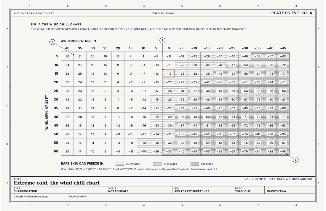
The body keeps a thin layer of warm air next to the skin. Wind strips it away and carries heat off faster than still air would, so a cold wind makes bare skin lose heat as it would at a much lower temperature in calm air. The wind chill is that temperature. The Weather Service's index, introduced in 2001, works it from the air temperature and the wind, by the equation below. It is built on a model of a human face, reckons the wind at 5 ft (1.5 m), the height of an adult's face, from the anemometer's reading at the standard 33 ft (10 m), and assumes no sun: a clear night sky. Bright sunshine may raise the wind chill by 10 to 18 °F (5.6 to 10 °C). The index is defined only at or below 50 °F (10 °C), and for winds above 3 mph.
At 0 °F (−17.8 °C) in a 15 mph wind, the wind chill is −19 °F (−28.3 °C), and bare skin can freeze in 30 minutes. Fig. A sets out the Weather Service's whole chart, with the time bare skin takes to freeze in each cell: 30 minutes, 10 or 5. Fig. C draws a face in a 25 mph wind at −5 °F (−20.6 °C), where the wind chill is −31 °F (−35 °C).
What wind chill is not
Wind chill applies only to people and animals. A car's radiator or a water pipe in the wind cools faster, but only to the air's own temperature: at −5 °F, the radiator in Fig. C cools no lower than −5 °F, though the wind chill is −31 °F. In the same way, frostbite needs the air itself below freezing. A wind chill below freezing on a day when the air is above it cannot freeze the skin, though it can still bring on hypothermia.
Frostbite and hypothermia
Frostbite is the freezing of the skin and the tissue beneath it; the parts most prone to it are uncovered skin and the hands and feet. Hypothermia comes when the body loses heat faster than it can make it, and in extreme cold a person can succumb to it in minutes; with prolonged exposure it can come even in cold short of the warning. The Weather Service's examples of each product name both: "Frostbite and hypothermia will occur if unprotected skin is exposed to these temperatures."
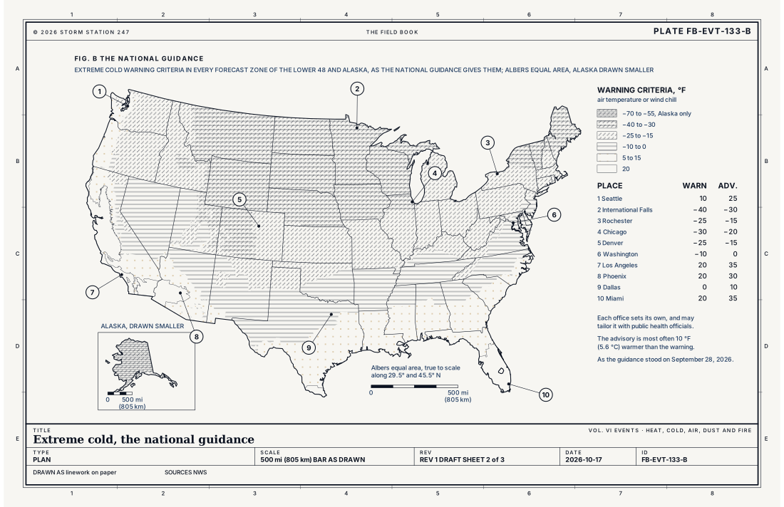
- Seattle: warning 10 °F (−12.2 °C), advisory 25 °F (−3.9 °C)
- International Falls, Minnesota: warning −40 °F (−40 °C), advisory −30 °F (−34.4 °C)
- Rochester, New York: warning −25 °F (−31.7 °C), advisory −15 °F (−26.1 °C)
- Chicago: warning −30 °F (−34.4 °C), advisory −20 °F (−28.9 °C)
- Denver: warning −25 °F (−31.7 °C), advisory −15 °F (−26.1 °C)
- Washington: warning −10 °F (−23.3 °C), advisory 0 °F (−17.8 °C)
- Los Angeles: warning 20 °F (−6.7 °C), advisory 35 °F (1.7 °C)
- Phoenix: warning 20 °F (−6.7 °C), advisory 30 °F (−1.1 °C)
- Dallas: warning 0 °F (−17.8 °C), advisory 10 °F (−12.2 °C)
- Miami: warning 20 °F (−6.7 °C), advisory 35 °F (1.7 °C)
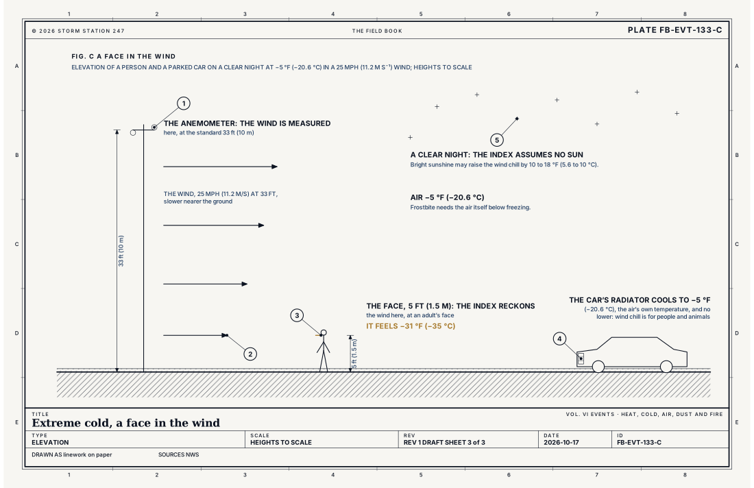
- The anemometer, at 33 ft (10 m)
- The wind, slower nearer the ground
- The face, at 5 ft (1.5 m): a wind chill of −31 °F (−35 °C)
- The radiator: −5 °F (−20.6 °C), the air's own temperature
- A clear night, the sky the index assumes
Ingredients
- An arctic air mass carried south from high latitudes behind a cold front
- Wind, which carries heat away from bare skin faster than still air
- A clear, calm night, which lets the ground lose its heat to space
- Snow on the ground, which loses heat readily and keeps the air above it cold
Scales
- time
- hours to days; the coldest around dawn, after a clear, calm night
- horizontal
- a region under an arctic air mass, hundreds to more than a thousand miles across
- vertical
- the coldest air lies in a shallow layer at the ground, under a temperature inversion
- orlanski
- macro-alpha to macro-beta for the air mass that brings it
Equations
The wind chill
- the wind chill temperature, °F
- the air temperature, °F
- the wind speed at the standard 33 ft (10 m), mph
Assumes The National Weather Service's 2001 index, defined only at or below 50 °F (10 °C) and for winds above 3 mph. It is built on a model of a human face and the heat it loses to the wind, reckons the wind at 5 ft (1.5 m) from the reading at 33 ft (10 m), and assumes no sun, a clear night sky. It applies to people and animals only.
Working form At 0 °F (−17.8 °C) in a 15 mph (6.7 m s⁻¹) wind, the wind chill is −19.4 °F (−28.6 °C), which the Weather Service's chart prints as −19: bare skin can freeze in 30 minutes. At −20 °F (−28.9 °C) in a 25 mph (11.2 m s⁻¹) wind it is −50.8 °F (−46.0 °C), and bare skin can freeze in 10 minutes.
Signatures
- surface
- the temperature falling through a clear; calm night; a north or northwest wind behind an arctic front; a very low dew point
- satellite
- clear sky over snow cover behind the front; the cold air too dry and shallow for cloud
- radar
- nothing; the air is clear and dry
- sounding
- a shallow; very cold layer at the ground under a strong inversion
Numbers
| Quantity | Value, and the kind of number it is |
|---|---|
| Extreme Cold Warning | Air temperatures or wind chill values reaching or exceeding locally defined warning criteriaStandard, Directive 10-515 |
| Extreme Cold Watch | Conditions favorable for air temperatures or wind chill values to meet or exceed local Extreme Cold Warning criteriaStandard, Directive 10-515 |
| Cold Weather Advisory | Air temperatures or wind chill values reaching or exceeding locally defined advisory criteria, but not exceeding warning criteriaStandard, Directive 10-515 |
| The national guidance | Not a strict set of rules; each office is encouraged to work with local public health officials and other partners to tailor its criteriaStandard, Directive 10-515 |
| Warning criteria in the lower 48 | From −40 °F (−40 °C) to 20 °F (−6.7 °C), air temperature or wind chill, across 3,850 forecast zonesStandard, National Weather Service Guidance for Extreme Cold Warnings and Cold Weather Advisories |
| The coldest criteria | −40 °F (−40 °C) in parts of Minnesota, Montana, the Dakotas and WyomingStandard, National Weather Service Guidance for Extreme Cold Warnings and Cold Weather Advisories |
| The warmest criteria | 20 °F (−6.7 °C) in parts of California, Arizona, Florida and TexasStandard, National Weather Service Guidance for Extreme Cold Warnings and Cold Weather Advisories |
| Advisory criteria | 10 °F (5.6 °C) warmer than the warning in 3,575 of the 3,818 zones of the lower 48 given bothStandard, National Weather Service Guidance for Extreme Cold Warnings and Cold Weather Advisories |
| Warning criteria in Alaska | As cold as −70 °F (−56.7 °C), in 21 of its 119 zonesStandard, National Weather Service Guidance for Extreme Cold Warnings and Cold Weather Advisories |
| Rochester, New York | Warning at −25 °F (−31.7 °C) or below; advisory from −15 to −24 °F (−26.1 to −31.1 °C)Standard, Wind Chill Temperature Index (2001) |
| Wind chill index | Defined only at or below 50 °F (10 °C) with wind above 3 mph (1.3 m s⁻¹)Standard, Wind Chill Temperature Index (2001) |
| The wind it uses | Reckoned at 5 ft (1.5 m), the height of an adult's face, from the reading at 33 ft (10 m)Standard, Wind Chill Temperature Index (2001) |
| Bright sunshine | May raise the wind chill by 10 to 18 °F (5.6 to 10 °C)Standard, Wind Chill Temperature Index (2001) |
| Frostbite | Only when the air itself is below freezing, whatever the wind chillStandard, Wind Chill Temperature Index (2001) |
| Where frostbite strikes first | Uncovered skin and the extremities, such as the hands and feetStandard, Cold Weather Safety |
| Hypothermia | The body losing heat faster than it can produce it; in extreme cold it can come in minutesStandard, Cold Weather Safety |
| What wind chill does to things | Cools them only to the air temperature, faster; a car's radiator at −5 °F (−20.6 °C) cools no lower, though the wind chill is −31 °F (−35 °C)Standard, Wind Chill Temperature Index (2001) |
How the station sees it
Every place on this site gives what the weather feels like, and at or below 50 °F that is the wind chill, worked by the same 2001 equation from the temperature and the wind the page gives beside it. The airport stations report both every minute, so the wind chill they give follows each gust. Where an office has an Extreme Cold Warning, Watch or Cold Weather Advisory in force, the place's page carries it, and each alert has its own report.
- Airport weather stations: the temperature and the wind every minute, from which each place's feels-like figure is worked
- Every station on the map: all the instruments that report temperature, ranked on how well they report
- Severe Alerts: every Extreme Cold Warning and Watch and Cold Weather Advisory in force, each with its own report
How it is warned
An Extreme Cold Warning is issued when the air temperature or the wind chill is expected to reach the office's warning criteria; an Extreme Cold Watch when those conditions are possible but their occurrence, location or timing is still uncertain; a Cold Weather Advisory for dangerously cold conditions that are not expected to reach the warning. The directive's national guidance is not a strict set of rules: each office is encouraged to work with local public health officials and other partners to tailor its criteria.
Most often an office's advisory sits 10 °F (5.6 °C) above its warning: it does in 3,575 of the 3,818 forecast zones of the lower 48 that are given both. In Rochester, New York, a warning is issued when the temperature, with or without wind, is expected to fall to −25 °F (−31.7 °C) or below, and an advisory when it is expected to fall between −15 and −24 °F (−26.1 and −31.1 °C). Duluth's office, where the warning criteria are −40 °F (−40 °C), gave its warning for wind chills "as low as 45 to 50 degrees below zero"; Denver's office, where the advisory criteria are −15 °F (−26.1 °C) and the warning −25 °F (−31.7 °C), gave its advisory for "very cold temperatures as low as 20 below zero".
During extreme cold, avoid going outside. If you must, dress in layers, cover every bit of bare skin with a hat, a face mask and gloves, and make sure someone knows where you are. Check on older relatives, friends and neighbors, and bring pets indoors. Use portable heaters correctly, and never run a generator or a grill indoors. To keep pipes from freezing, wrap them, drain them or let them drip slowly. Keep at least half a tank of fuel in the car.
| VTEC | Phenomenon | The alerts that carry it |
|---|---|---|
CW | cold weather | Cold Weather Advisory |
EC | extreme cold | Extreme Cold Warning; Extreme Cold Watch |
See also
- Frost, freeze and hard freeze FB-EVT-092
- Cold wave and arctic outbreak FB-EVT-132
- Blizzard FB-EVT-081
- Wind chill event FB-EVT-093
- How to read a warning FB-STN-001
Sources
- National Weather Service. Directive 10-515, WFO Non-Precipitation Weather Products Specification.
- National Weather Service. National Weather Service Guidance for Extreme Cold Warnings and Cold Weather Advisories, Directive 10-515 Appendix B.
- National Weather Service. Wind Chill Temperature Index (2001).
- National Weather Service. Understanding Cold Weather Alerts.
- National Weather Service. Cold Weather Safety.
Definition after the Directive 10-515, WFO Non-Precipitation Weather Products Specification. Plate FB-EVT-133, revision 1, 2026-10-17. The number is permanent; cite it.