What it is
High surf is large waves breaking on or near the shore. Most often the waves come from far away: a storm over the open ocean, days before and thousands of miles off, sends out swell that crosses the sea and breaks on every shore that faces it, sometimes under a clear sky and a light wind. The waves can knock people off rocks and jetties, sweep them from beaches and wash over coastal roads.
The Weather Service warns it with a High Surf Advisory when breaking waves in the surf zone threaten life and property along the coast, and a High Surf Warning when the threat is especially high. Each office sets the wave heights for its own shores, because the same surf that is ordinary on one shore is dangerous on another. In Hawaii, the Honolulu office issues an advisory for surf of 15 ft (4.6 m) on north-facing shores and a warning for 25 ft (7.6 m); Fig. B sets out all of its shores.
What it is not
It is not a rip current, Rip current FB-EVT-108, though high surf drives strong rips and its advisory may name them.
It is not a coastal flood, Coastal flood FB-EVT-105: water over land from the tide and the surge. Large surf on a high tide can carry water over the beach and onto roads, which joins the two.
It is not hazardous seas, Hazardous seas FB-EVT-114: steep, dangerous waves out on the water, a danger to boats. High surf is the waves breaking at the shore.
Lookalikes
- Rip current
- The flow that breaking waves drive out to sea, Rip current FB-EVT-108. High surf often brings rip currents, and its advisory may name them.
- Coastal flood
- Water over land from the tide and the surge, Coastal flood FB-EVT-105. Large surf on a high tide can carry water over the beach and onto roads.
- Hazardous seas
- Steep, dangerous waves out on the water, for boats, Hazardous seas FB-EVT-114. High surf is the waves breaking at the shore.
Machine
Wind makes waves, and waves become swell
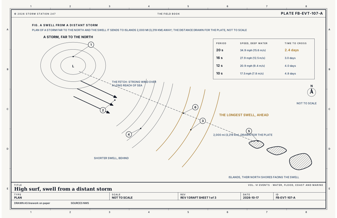
Wind blowing over the sea raises waves, and the longer it blows, the farther it blows over open water and the stronger it is, the larger and longer the waves grow. The reach of sea the wind blows over is the fetch. Out of the storm, the waves sort themselves: the long waves run ahead and the short ones fall behind, and what crosses the ocean is swell, smooth, regular and long.
The long waves arrive first
In deep water a group of waves, and the energy it carries, moves at a speed set by its period alone. The equation below gives it. A 20 second swell crosses 2,000 mi (3,219 km) of ocean in 2.4 days, at 34.9 mph (15.6 m/s); a 10 second swell takes 4.8 days. Fig. A draws it. So the first sign of a big swell at the shore is a few long, slow waves, often hours before the largest, and the period shortens as the rest arrives. Swell from a storm far to the north reaches Hawaii's north shores days later.
Breaking at the shore
As swell runs into shallow water it slows, its waves crowd together and grow taller, until each one grows too steep and breaks. A shore with deep water close in takes the swell's whole height at once; the waves rise and break suddenly over the reef or the bar. Long period swell grows the most as it reaches the shore. The Honolulu office measures surf by the full face of the breaking wave, from the trough in front of it to its crest, and Fig. C draws a 25 ft (7.6 m) face beside a person to the same scale.
Sets, and sneaker waves
Swell from more than one storm, or of more than one period, arrives in groups: a set of larger waves, then a lull. A lull can last long enough that people walk out onto rocks or the wet sand, and the next set catches them. The Weather Service calls a large wave that suddenly swamps a beach or coast and takes people by surprise a sneaker wave, and counts the deaths it causes apart from those of high surf and rip currents.
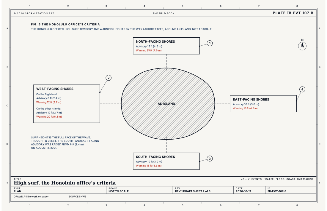
- North-facing shores
- West-facing shores
- South-facing shores
- East-facing shores
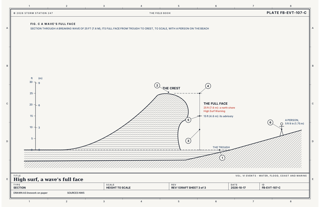
- The trough
- The crest
- The full face, trough to crest
- A north shore warning, 25 ft (7.6 m)
- Its advisory, 15 ft (4.6 m)
- A person, 5 ft 9 in (1.75 m)
Ingredients
- A storm with strong wind blowing over a long reach of sea, for a long time
- Open ocean between the storm and the shore, so the swell arrives with little lost
- A shore that faces the swell, with deep water close to it
- Long period swell, which carries its energy fastest and grows the most as it reaches shallow water
Scales
- time
- days for a swell to cross the ocean, and to build and fade at the shore
- horizontal
- a swell crosses thousands of miles of ocean; it breaks on every shore that faces it
- vertical
- a breaking wave's full face from a few feet to tens of feet, trough to crest
- orlanski
- meso-alpha to macro-beta for the swell; micro-beta for the breaking wave
Equations
How fast swell crosses deep water
- the speed of a group of waves, and of their energy, in deep water, ft s⁻¹
- the acceleration of gravity, 32.17 ft s⁻² (9.81 m s⁻²)
- the wave period, the time between one crest and the next passing a point, s
Assumes Linear waves in deep water, where the water is deeper than half the wavelength. The waves themselves travel twice as fast as the group, appearing at its back and dying out at its front, so it is the group, and its energy, that crosses the ocean at this speed.
Working form A 20 second swell crosses deep water at 34.9 mph (15.6 m/s), and covers 2,000 mi (3,219 km) in 2.4 days; a 16 second swell at 27.9 mph (12.5 m/s), in 3.0 days; a 10 second swell at 17.5 mph (7.8 m/s), in 4.8 days. The longest swell arrives first, and its period shortens as the rest arrives.
Signatures
- surface
- the waves at the buoys offshore growing; their period long; the larger waves arriving in sets
- satellite
- a deep storm over the open ocean; days before; with a long fetch aimed at the coast
- radar
- nothing; the waves are far below the beam
- sounding
- nothing; the cause is far away
Numbers
| Quantity | Value, and the kind of number it is |
|---|---|
| High Surf Advisory | Breaking wave action in the surf zone a threat to life and property along the coastStandard, Directive 10-320 |
| High Surf Warning | Breaking wave action an especially heightened threat to life and property along the coast; issued at the option of each regionStandard, Directive 10-320 |
| High surf and rip currents | Rip current information may be included, or a Rip Current Statement issued with it in one productStandard, Directive 10-320 |
| North-facing shores of Hawaii | Advisory 15 ft (4.6 m); warning 25 ft (7.6 m)Standard, High Surf Advisory and Warning Information |
| West-facing shores of the Big Island | Advisory 8 ft (2.4 m); warning 12 ft (3.7 m)Standard, High Surf Advisory and Warning Information |
| West-facing shores of the other islands | Advisory 12 ft (3.7 m); warning 20 ft (6.1 m)Standard, High Surf Advisory and Warning Information |
| South- and east-facing shores of Hawaii | Advisory 10 ft (3.0 m); warning 15 ft (4.6 m); the advisory raised from 8 ft (2.4 m) on August 2, 2021Standard, High Surf Advisory and Warning Information |
| Surf height | The full face of the wave, from the trough to the crestStandard, High Surf Advisory and Warning Information |
| High surf, as the Weather Service counts deaths | Large waves breaking on or near the shore resulting from swells spawned by a distant stormStandard, Surf Zone Fatalities in the United States |
| A sneaker wave | A large wave that suddenly swamps a beach or coast and takes people by surprise, sweeping them into the waterStandard, Surf Zone Fatalities in the United States |
How the station sees it
Where an office writes a Surf Zone Forecast, it gives the surf height for each day, as a range such as 3 to 5 feet, and each beach on this site carries it, with the waves at its nearest buoy: their height, their period and the direction they come from. A long period and a direction facing the beach are the signs that big surf is on the way; the buoys far offshore see the swell hours before it reaches the beach.
- Beaches: every beach, with the surf in its forecast and the waves at its nearest buoy: their height, period and direction
- Severe Alerts: every High Surf Advisory and Warning in force, each with its own report
How it is warned
A High Surf Advisory is issued when breaking waves in the surf zone become a threat to life and property along the coast, and a High Surf Warning when the threat is especially high, at heights each office sets; warnings are issued where each region chooses. Rip current information may be included in the advisory or warning, or a Rip Current Statement issued with it in one product.
During high surf, stay off rocks, jetties and seawalls the waves reach, keep well back from the water's edge, and never turn your back on the ocean. Stay out of the water unless you are an experienced surfer or swimmer who knows the place, and even then, ask the lifeguards.
| VTEC | Phenomenon | The alerts that carry it |
|---|---|---|
SU | high surf | High Surf Advisory; High Surf Warning |
See also
- Rip current FB-EVT-108
- Coastal flood FB-EVT-105
- Hazardous seas FB-EVT-114
- Waves and swell FB-WAT-041
- How to read a warning FB-STN-001
Sources
- National Weather Service. Directive 10-320, Surf Zone Forecast and Coastal/Lakeshore Hazard Services.
- National Weather Service. High Surf Advisory and Warning Information, the Honolulu office.
- National Weather Service. Surf Zone Fatalities in the United States.
- Dean, R. G. and R. A. Dalrymple. Water Wave Mechanics for Engineers and Scientists (1991).
Definition after the Directive 10-320, Surf Zone Forecast and Coastal/Lakeshore Hazard Services. Plate FB-EVT-107, revision 1, 2026-10-17. The number is permanent; cite it.