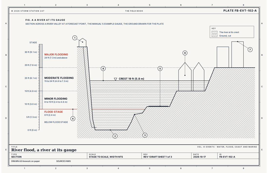
What it is
A river flood is a river risen over its flood stage. Every point on a river that the Weather Service forecasts has a gauge, and every gauge has a flood stage: the height on it at which the rising water begins to reach roads, homes, farms and businesses. Above it the flooding is named in three categories, set for that point from what the water reaches there. Minor flooding brings little or no damage, though roads go under. Moderate flooding reaches buildings and roads near the river, and people leave or move their belongings to higher ground. Major flooding covers buildings and roads widely, and many people leave. A flood at or above the highest stage ever measured at the gauge is record flooding, whatever its category.
A river flood comes slowly. Rain falls for a day or several over a basin of hundreds or thousands of square miles, or snow melts across it, and the water gathers into the river over days. The crest, the highest stage of the flood, then travels down the river, reaching each point a little later than the one above it. A river can stay over its flood stage for days, and the largest for weeks.
Fig. A draws the example gauge of the Weather Service's own manual: flood stage at 8 ft (2.4 m), minor flooding from 8 to 15 ft (2.4 to 4.6 m), moderate from 15 to 24 ft (4.6 to 7.3 m) and major from 24 ft (7.3 m). The numbers are the manual's; every forecast point has its own.
What it is not
It is not a flash flood. Water that rises fast, generally within 6 hours of its cause, in a small steep basin, a city street or below a failed dam, is a flash flood and is warned by a Flash Flood Warning, Flash flood FB-EVT-100. A river flood rises over days, and its warning usually comes before the water does.
It is not an areal flood. A Flood Warning can also be issued for an area: streams, fields and low ground flooding over hours where no gauge stands to measure them. That is Areal flood FB-EVT-101. This plate is a flood at a point on a river, with a gauge, a stage and a forecast crest.
It is not a coastal flood. Water pushed onto the shore by the tide and the wind is Coastal flood FB-EVT-105. Near the mouth of a river the two can come together, and the office says so in its warning.
Lookalikes
- Flash flood
- Water that rises fast, generally within 6 hours of its cause, in a small steep basin or a city. Its warning is a Flash Flood Warning, Flash flood FB-EVT-100. A river flood rises over days.
- Areal flood
- A Flood Warning can also cover an area: streams and low ground flooding over hours, with no forecast point to measure them. That is Areal flood FB-EVT-101. This plate is a flood at a point on a river, with its gauge, its stage and its crest.
- Coastal flood
- Water from the sea, driven by the tide and the wind, Coastal flood FB-EVT-105. Near the mouth of a river both can come together, and an office says so in its warning.
Machine
A basin gathers its water
Every drop of rain that falls on a basin and is not taken in by the ground, the plants or the air runs downhill toward the same river. The larger the basin, the longer the water takes to arrive, and the more of the rain from a long storm it gathers. Ground already soaked, or frozen, takes in little, so the same rain floods a river in spring that would not in late summer. Snowmelt adds water for days without any rain at all, and rain on melting snow adds both. The whole cycle of the water is drawn on The hydrologic cycle FB-WAT-030, and the melt on Melt and runoff FB-WAT-032.
The crest travels
Fig. B draws one flood at the gauge of Fig. A. The rain falls on the first day. The river rises slowly at first, then faster as the water from the far parts of the basin arrives, crosses flood stage and reaches its crest at four days, 19 ft (5.8 m), moderate flooding. It falls more slowly than it rose, because the water spread over the floodplain drains back to the channel, and it is back below flood stage almost three days after the crest. A point downstream sees the same flood later and, where tributaries join, larger.
Deeper water moves faster
The equation below, Manning's, gives the speed of water flowing in an open channel. In a wide river 10 ft (3.0 m) deep, with the slope and roughness of a large river, it moves 4.42 ft s⁻¹ (3.01 mph); at 20 ft (6.1 m) deep, 7.01 ft s⁻¹ (4.78 mph). Twice the depth carries 3.17 times the water. This is why the last few feet of a rise carry so much more than the first, and why water moving over a road a foot deep, 12 in (30 cm), can carry away a small car.
The floodplain
Once the river is over its banks, the water spreads across the floodplain, the flat ground beside the channel that past floods built. The water there is shallower and slower, slowed by fields, fences, trees and buildings, and the river's rise slows because each foot of stage now covers far more ground. Levees hold the water off the land behind them until they are overtopped or fail, and then that land can fill quickly. An ice jam does the opposite: it dams the river, and the water rises behind it within hours.
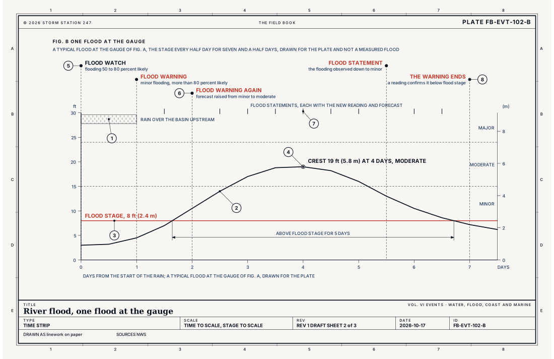
- The rain over the basin upstream
- The stage at the gauge
- Flood stage, 8 ft (2.4 m)
- The crest, 19 ft (5.8 m), moderate flooding
- The Flood Watch
- The Flood Warning, raised to moderate
- The Flood Statements
- The warning's end
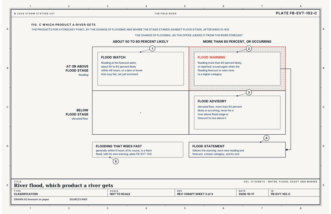
- Flood Watch
- Flood Warning
- Flood Advisory
- Flood Statement
- A flash flood, warned on its own
Ingredients
- Rain over days on a large basin, or heavy rain on ground already wet or frozen
- Snow melting, alone or with rain falling on it
- A river already high, so the next rain brings it over flood stage
- Or an ice jam that dams the river, or a dam or levee that fails
Scales
- time
- days to weeks, from the rain to the crest and back below flood stage
- horizontal
- a basin of hundreds to tens of thousands of square miles, its crest travelling hundreds of miles down the river
- vertical
- a stage from a few feet to tens of feet above flood stage
- orlanski
- meso-beta to meso-alpha
Equations
Manning's equation, in U.S. units
- the mean speed of the water, ft s⁻¹
- the roughness of the channel, Manning's n
- the hydraulic radius, the area of the flow divided by the wetted edge of the channel, ft; in a wide river nearly its depth
- the slope of the water surface, ft per ft
Assumes Steady flow in a channel so wide that its hydraulic radius is its depth, with one roughness at every depth. The factor 1.49 is the cube root of 3.28 ft per metre; in metres the equation is the same with 1 in its place. A real river spills onto a floodplain rougher than its channel, so a gauge's rating, its stage against its flow, is measured, not computed.
Working form In a wide channel with n = 0.035 and a slope of 2.64 ft a mile (0.0005), water 10 ft (3.0 m) deep moves 4.42 ft s⁻¹ (3.01 mph, 1.35 m s⁻¹) and carries 44.2 ft³ s⁻¹ for each foot of width (4.10 m³ s⁻¹ a metre); 20 ft (6.1 m) deep, 7.01 ft s⁻¹ (4.78 mph, 2.14 m s⁻¹) and 140.3 ft³ s⁻¹ (13.03 m³ s⁻¹ a metre). Twice the depth is 1.59 times as fast and 3.17 times the flow.
Signatures
- surface
- a river gauge rising day after day; its forecast crest above flood stage; rain gauges upstream with a day's or several days' rain; snow melting in the basin
- radar
- rain over the basin for a day or more; the totals the radar estimates large over the whole of it
- satellite
- a slow storm or a stalled front over the basin; later; the river and its floodplain wide with water
- sounding
- deep moisture; the air holding much more water than usual; over days
Numbers
| Quantity | Value, and the kind of number it is |
|---|---|
| Flood stage | The gage height at which a rise begins to impact lives, property or commerce; not necessarily bankfull stageStandard, Manual 10-950 |
| Bankfull stage | The gage height above which the river overflows its lowest natural bank somewhere in its reachStandard, Manual 10-950 |
| Action stage | The gage height at which action is taken to prepare for possible significant hydrologic activityStandard, Manual 10-950 |
| Minor flooding | Minimal or no property damage, but possibly some public threat, such as roads under waterStandard, Manual 10-950 |
| Moderate flooding | Some structures and roads near the stream under water; people evacuated or property moved to higher groundStandard, Manual 10-950 |
| Major flooding | Extensive inundation of structures and roads; significant evacuations of people or property moved to higher groundStandard, Manual 10-950 |
| Record flooding | At or above the highest stage or flow observed at the site in its period of record, in any category, or below them all where the record is shortStandard, Manual 10-950 |
| The manual's example gauge | Flood stage 8 ft (2.4 m); minor 8 to 15 ft (2.4 to 4.6 m); moderate 15 to 24 ft (4.6 to 7.3 m); major 24 ft (7.3 m) and above; each forecast point has its ownStandard, Manual 10-950 |
| Flood Warning | Flooding at a forecast point more than 80 percent likely, or reported; issued again when the flooding forecast or observed rises to a higher categoryStandard, Directive 10-922 |
| Flood Watch | Flooding about 50 to 80 percent likely within 48 hours, or a dam or levee that may fail with the threat not yet imminentStandard, Directive 10-922 |
| Flood Advisory | Elevated streamflow occurring or more than 80 percent likely; never for a river above flood stage or forecast to rise above itStandard, Directive 10-922 |
| Flood Statement | Follows a Flood Warning with each new reading and forecast, a fall to a lower category, and its endStandard, Directive 10-922 |
| Manning's n | About 0.03 for a clean, straight channel and 0.035 for a large river; more for a floodplain of brush or treesTypical |
| Moving water that carries away a small car | 12 in (30 cm)Standard, Turn Around Don't Drown |
| The site's gauges | The stage as each gauge reports it, as often as every 15 minutes: the height of the water above the gauge's own zero, not its depthThis site |
How the station sees it
A river gauge measures the stage: the height of the water's surface above the gauge's own zero, which is usually set near the bed of the channel, so the stage is not the depth of the water. Some gauges set their zero at a datum such as sea level instead, and read hundreds of feet. Where a gauge reports its flow, in cubic feet a second, the flow is read from the stage by the gauge's rating, a curve made from many measurements of the flow at different stages. The river and lake gauges on this site report their stage as often as every 15 minutes, with its change over a day and its last 30 days.
The Weather Service's River Forecast Centers forecast the stage at each forecast point days ahead, from the rain that has fallen, the rain expected, the snow and the state of the ground, and the office near the river issues the products from those forecasts. The site's record of severe weather keeps every river point an office warns will flood, with its category, its forecast crest, the highest stage reported and its flood stage, as the office gave them.
- River and lake gauges: the stage, as often as every 15 minutes, its change over a day and its last 30 days
- River and stream gauges on the map: each gauge that reports by satellite or radio
- Volunteer rain gauges: the rain over the basin, measured each morning
- The record of severe weather: every river point warned to flood, its category, its crest and its flood stage
How it is warned
A Flood Watch may be issued when flooding at a forecast point is about 50 to 80 percent likely within 48 hours, or when a dam or levee may fail and the threat is not yet imminent. A Flood Warning is issued when the flooding is more than 80 percent likely or is reported, and it is issued again, under a new headline, when the flooding forecast or observed rises to a higher category. Flood Statements follow the warning with each new reading and forecast, tell when the flooding falls to a lower category and end the warning once a reading confirms the river is back below flood stage. Some offices issue a Flood Advisory for a river running high but forecast to stay below flood stage. Fig. C sets them side by side.
Each warning names its point on the river, its flood stage, the latest stage and the forecast crest, with what that stage floods there. Its code line carries the gauge's identifier, the category, what caused the flood and the times it is forecast to begin, crest and end.
When a Flood Warning is issued for a river near you, move belongings and vehicles to higher ground before the water comes, and leave when told to. Never drive or walk into flood water: turn around, don't drown. Water over a road can hide a road that is already gone.
| VTEC | Phenomenon | The alerts that carry it |
|---|---|---|
FL | flood (point) | Flood Advisory; Flood Statement; Flood Warning; Flood Watch |
Weather radio (SAME) codes: FLA FLW FLS
See also
- Flash flood FB-EVT-100
- Areal flood FB-EVT-101
- Heavy rain and training storms FB-EVT-022
- Tropical rainfall flood FB-EVT-048
- The hydrologic cycle FB-WAT-030
- Melt and runoff FB-WAT-032
- Coastal flood FB-EVT-105
- How to read a warning FB-STN-001
- Watch, warning and advisory FB-STN-004
Sources
- National Weather Service. Manual 10-950, Definitions and General Terminology.
- National Weather Service. Directive 10-922, Weather Forecast Office Hydrologic Products Specification.
- National Weather Service. Directive 10-1703, Valid Time Event Code (VTEC).
- National Weather Service. Flood Related Hazards.
- National Weather Service. Turn Around Don't Drown.
- Chow, V. T., D. R. Maidment and L. W. Mays. Applied Hydrology (1988).
Definition after the Manual 10-950, Definitions and General Terminology. Plate FB-EVT-102, revision 1, 2026-10-17. The number is permanent; cite it.